Given the possible impact of Hurricane Kay, the Government calls for extreme caution

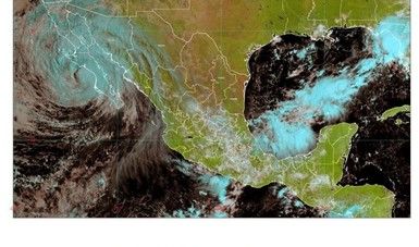
Hurricane Kay intensified to category 2, its center is located 370 km from Baja California Sur; its cloud bands will leave rain in Sinaloa and Sonora.

Given the possible impact of Hurricane Kay, the Government calls for extreme caution
The Mexican government urges everyone to exercise utmost caution in the face of Hurricane Kay. Credit: Conagua

Due to the forecast that Hurricane Kay, category 1 on the Saffir-Simpson scale, will make landfall this afternoon in the municipality of Mulegé (between Bahía de Asunción and Punta Eugenia), the population must take extreme precautions in the face of this natural phenomenon.

This was informed during the press videoconference where the Government of Mexico urged state and municipal authorities to implement promptly the necessary prevention and civil protection strategies to reduce, as much as possible, the effects on the population and their property, as a consequence of the possible impact of Hurricane Kay. The population in general was urged to remain attentive to official meteorological information and to heed the indications of Civil Protection.

During the videoconference with the participation of representatives from the National Water Commission (Conagua), the Secretary of the Navy (SEMAR), and the National Civil Protection Coordination (CNPC), the general coordinator of the National Meteorological Service (SMN), Alejandra Margarita Méndez Girón, informed that this morning the center of Hurricane Kay was located 185 kilometers (km) northwest of Cabo San Lázaro, and 255 km south-southeast of Punta Eugenia, Baja California Sur. It presented maximum sustained winds of 140 kilometers per hour (km/h), gusts of 165 km/h, and is moving towards the north-northwest at 24 km/h.

Kay's cloud bands generated extraordinary punctual rains (accumulated rains greater than 250 millimeters [mm]) in the Baja California Peninsula; heavy rains (from 75 to 150 mm) in Sonora, very heavy rains (from 50 to 75 mm) in Sinaloa, and showers (from 5 to 25 mm) in Chihuahua and Durango.

Likewise, Kay will continue to produce wind gusts of 120 to 150 km/h on the west coast of Baja California and Baja California Sur; gusts of 100 to 120 km/h in the Gulf of California; gusts of 80 to 100 km/h on the coast of Sonora and gusts of 60 to 80 km/h on the north coast of Sinaloa.

In addition, swells of 7 to 9 meters (m) in height are forecast on the west coast of Baja California Sur and Baja California; 2 to 4 m in the Gulf of California and the coast of Sonora, and 1 to 3 m on the coasts of Colima, Jalisco, Michoacán, Nayarit, and Sinaloa.

Méndez Girón pointed out that, during this night and early Friday morning, Kay will enter again over Pacific waters and will continue its trajectory as a tropical storm, parallel to the coasts of Baja California, with a separation of the center of the system of 50 km from the coast, covering with its bands the municipalities of San Quintín, San Felipe, Ensenada, Mexicali, Tecate, Tijuana and Playas de Rosario in Baja California.

During Saturday, Kay is expected to degrade to a remnant low pressure off the coast of Ensenada, Baja California.

During its journey, Kay will continue to cause extraordinary rains in the Baja California Peninsula, heavy rains in Sonora, very heavy rains in Sinaloa, and heavy rains in Chihuahua and Durango.

In total, he said, from September 8 to 10, accumulated rains of 250 to 300 mm are expected in Baja California and 250 to 350 mm in Sinaloa and Sonora. He emphasized the importance of being attentive to the growth of rivers and streams since September is the month in which historically more rains are registered in almost all of the country.

Conagua's Manager of Surface Water and River Engineering, Heriberto Montes Ortiz, assured that the development of the rains caused by Kay is being closely monitored, mainly in regions where there is soil saturation as a result of the recent rains. He emphasized that this work is carried out to inform promptly, in collaboration with the CNPC, on the levels of rivers, streams, and hydraulic storage infrastructure in the country.

Special attention is being paid to dams and rivers located in Baja California, Baja California Sur, Chihuahua, Durango, Sinaloa, and Sonora.

Specifically, the rains caused by Kay could increase the flow of rivers and streams, as well as cause flooding in low-lying areas, with the possibility of landslides and damage to roads and highways in the aforementioned states. For this reason, he urged the population of the states with rainfall forecasts to be attentive to the official warnings issued by the Conagua and to follow the recommendations issued by the CNPC.

On behalf of the Infrastructure Protection and Emergency Attention Management (PIAE), Hiram Velázquez Guevara emphasized that Conagua works in close coordination with the agencies that make up the National Civil Protection System, to comprehensively address emergencies that may arise as a result of the rains.

In the region where the greatest effects of Hurricane Kay are expected, Conagua has PIAE Brigades and specialized teams stationed at the Regional Emergency Attention Centers in La Paz, Baja California Sur; Los Mochis, Culiacán and Mazatlán, Sinaloa; and Ciudad Obregón, Sonora. He emphasized that, if necessary, support is also available from brigades assigned to nearby entities, such as Baja California, Colima, and Nayarit.

The head of the Subsection of Civil Protection and Contingencies of the Secretariat of the Navy, Captain Alberto Ek Moo, pointed out that for the next 24 hours, swells of 7 to 9 feet are expected on the northwest coast of the Baja California peninsula, 10 to 14 feet on the central-southwest coast of the peninsula, as well as swells of 7 to 12 feet in the Gulf of California.

At 48 hours, swells of 8 to 10 feet are expected on the central-northwest coast of the Baja California peninsula. Meanwhile, the 72-hour forecast indicates swells of 3 to 5 feet on the west coast of the Baja California peninsula.

On behalf of Laura Velázquez Alzúa, National Civil Protection Coordinator of the Ministry of Security and Citizen Protection, the director of the National Center of Communication and Operation of Civil Protection, Luis Alberto Ortega Vázquez, highlighted that the actions and preparation protocols of the authorities of the three levels of government were immediately activated to safeguard the population. Likewise, SEDENA, the Navy, and the National Guard activated Plan DNIII-E, Plan Marina, and Plan GN-A, respectively, to help the population; the State Civil Protection Council of Baja California and the municipalities are in session; public address campaigns are being carried out in vulnerable zones and risk identification, as well as the preventive evacuation of highly vulnerable localities and a Liaison and Coordination Mission (Misión ECO), remains in Baja California Sur to coordinate preparedness actions in the face of Kay's effects.

At 11:00 a.m., the CNPC issued a red alert due to the cyclone's passage, so it recommended the population not to leave their homes and, in case of living in an area that has been previously flooded or is considered at risk, to go to one of the 48 temporary shelters set up in Baja California Sur.

Weather conditions, recommendations, and mitigation measures can be consulted at https://smn.conagua.gob.mx/es/, www.gob.mx/cenapred, and www.preparados.gob.mx, as well as the official accounts @Conagua_Clima and @CNPC_MX.