The Sac Actun flooded cave system, in the Yucatan Peninsula

Sac Actun's preservation helps maintain the Yucatán Peninsula's natural environment, which in turn keeps visitors coming.
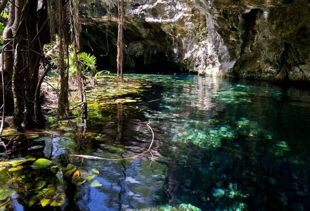
The Sac Actun flooded cave system, in the Yucatan Peninsula
Sac Actun, the first Mexican geosite among the 100 most important in the world. Images and text: UNAM

The Sac Actun flooded cave system, in the Yucatan Peninsula, was designated one of the 100 most important geosites in the world by the International Union of Geological Sciences (IUGS), an organization that represents more than one million geoscientists from the five continents.

The formal announcement was made on October 28th, during the IUGS conference in Zumaia, Spain. It is worth mentioning that this is the first time that a Mexican geosite is part of this list, which brings together key places with geological elements and/or processes of international scientific relevance.

Sac Actun is the world's longest-flooded cave system. It is 368 kilometers long and has the second largest cave after Mammoth Cave in Kentucky, United States. It is a sedimentary platform of Mesozoic and Cenozoic rocks with a thickness of up to 3,500 meters. It is estimated that there are more than seven thousand cenotes in the Yucatan Peninsula, several of them related to Sac Actun.

The Sac Actun flooded cave system was selected to be part of the IUGS Geological Heritage Sites due to its unique geological, geomorphological, and cultural history.

Located on the Yucatán Peninsula is the flooded cave system of Sac Actun.

Sac Actun geotope and biotope

Some time ago, several explorers began to explore Sac Actun, and little by little, they elaborated the first maps of the site, which later allowed others to enter into new passages.

"And the exploration continues, because every weekend people visit the site with their resources to make discoveries and generously report them to the Institute of Geology of the UNAM, among others," said López Martnez, who heads a group of university scientists studying the geosite.

It is an underwater ecosystem that is home to countless endemic organisms, such as some remipedes, a kind of very ancient blind crustacean (in fact, they are one of the first forms of life on Earth). It also sustains the ecosystem above it, i.e., the jungle, and even nourishes the Mesoamerican Reef System, one of the largest in the world, by transporting organic matter from it.

As if that were not enough, it provides almost all the freshwater consumed in the area since, as is well known, the Yucatan Peninsula has no rivers, and with its more than 85 interconnected cenotes, it boosts tourism.

"In sum, Sac Actun is a geotope, that is, a place with many geological elements, but it is also a biotope, a place with great biodiversity." Therefore, the preservation and conservation of this system of flooded caves are fundamental. By protecting it, we protect the entire ecosystem of the Yucatan Peninsula and, in addition, tourism. "What I am getting at is that it is not only about the caves themselves but also about the communities that depend on them for the freshwater they provide and the tourist activity they generate," added the researcher.

For Mexico, Sac Actun is the first geosite to make the list of the world's 100 most significant.

Multidisciplinary and transdisciplinary work

The Institute of Geology has the Carbonate and Karstic Processes Laboratory, the only one of its kind in Mexico, where López Martínez and some of his colleagues study the different components of the Sac Actun flooded cave system, as well as the soil above it and the geological evolution of the Yucatán peninsula.

"During the last glaciation, when the sea level was 150 meters below the current level, these caves remained above water." Hence, they have stalactites and stalagmites. However, approximately 10,000 years ago, the global temperature began to rise, so countless glaciers melted and the sea level rose, flooding them. "Therefore, Sac Actun is crucial to understanding how sea level has changed over the last 800,000 years," said López Martínez.

Now, the study of these caves is being carried out at the Institute of Geology and also at the Institutes of Geography, Geophysics, Marine Sciences, and Limnology, as well as at the Sisal Academic Unit of the UNAM's Institute of Engineering. "It is a multidisciplinary and transdisciplinary work that cannot be carried out only by geologists." Behind it is researchers from these other institutes because the objects of study are very varied," concluded the university researcher.

San Actun System Map

Karstic forms

The platform that constitutes today's Yucatan Peninsula began to emerge above sea level more than 20 million years ago. During the continental ascent, vertical movements caused fractures and, therefore, facilitated the subway development of karstic forms (cavities that take advantage of the stratification planes of the rocks). Most of the caves in the area emerged from the water table.

The extensive cave systems located under the Yucatan Peninsula have been guardians of hidden and priceless treasures. In their galleries and underwater passages, animal and human bones from the Pleistocene have been found.