A Guide to the State of Sinaloa, Mexico

This updated guide to Sinaloa will allow you to get to know and locate the places of interest in the northwestern region of Mexico.

A Guide to the State of Sinaloa, Mexico
Landmark in the State of Sinaloa, Mexico. Photo by Alejandro Cartagena 🇲🇽🏳‍🌈 / Unsplash

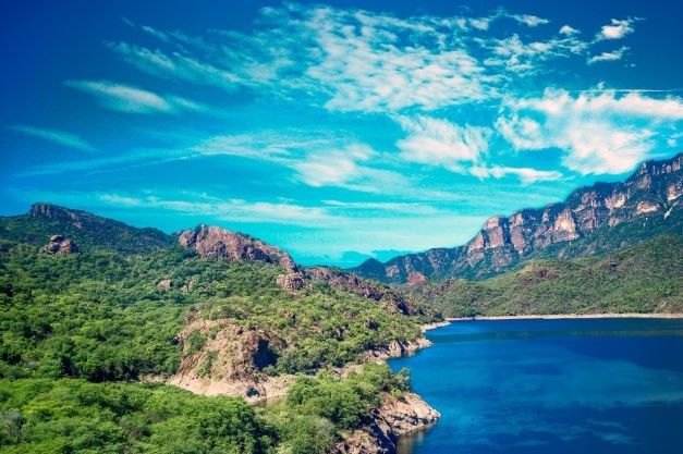
The State of Sinaloa, due to its geographic location, has become a privileged tourist destination, where the mountains and the coast frame the beauty of its multiple cultural attractions and natural resources. Where the pulsating of this land is reflected in the green valleys; for its fertile soil for agricultural, livestock, and fishing production. A place where every dawn caresses the humid mountains giving way to the light that awakens the joy of being from Sinaloa, a host who shares his land with those who visit and enjoy a world of joy and fun.

One of the most important tourist destinations of international fame is located in this prodigious land. Mazatlán is a charming center of incomparable beauty and is known throughout the world for its miles of uninterrupted fine sandy beaches and unforgettable sunsets. A place that offers visitors a variety of attractions to satisfy the most demanding tastes.

This guide to Sinaloa with updated data will allow you to know and locate each of the places of interest in this great region of the northwest of the Mexican Republic.  We hope the compilation of this material will be useful as a source of information and consultation of the beautiful State of Sinaloa and Mazatlán "The Pearl of the Pacific"; all to orient you so that you can attend to your objective by efficiently offering everything that facilitates the organization of your vacations.

Enjoy the diversity of tourist facilities, infrastructure, lodging establishments, colonial towns, and modern cities that offer a great number of cultural and recreational activities, a first-class road system, rich flora, and fauna, as well as a variety of climates and landscapes. Sinaloa is a state with everything and for everyone that awaits its visitors offering them the best it has to offer, the hospitality of its people.

Mazatlan beaches are full of tourists during Easter holidays.
Mazatlan is a perennial favorite for those fleeing the cold and looking for a warm and welcoming environment. Photo: Mazatlan.gob

Historical Facts about Sinaloa

Sinaloa in the Cahíta language means Pitahaya Redonda, a wild fruit that is abundant in the region. Sinaloa in the Cahíta language means Pitahaya Redonda, a wild fruit that is abundant in the region. The configuration of the people of Sinaloa arose from the precise mixture of races that occurred at the end of the last century between indigenous and mestizo groups, as a result of the Spanish conquest and the arrival of foreigners who came to these lands moved by the desire to find a suitable place to live in a prosperous way.

The various indigenous groups that inhabited what is today the territory of Sinaloa until the arrival of the Spaniards lived in a rather primitive social state, surviving by hunting, fishing, and fruit gathering. Hence, their presence was manifested in the innumerable vestiges that leave us their most faithful testimonies engraved in stone, the so-called "petroglyphs"; figures made in the rocks, chiseled, or perforated with smaller stones. Although Sinaloa is not located in the center where the main pre-Hispanic settlements were established, its territory was included in Mexico's pre-Columbian era and played an important role in the history and development of the country.

At the beginning of the 16th century, the region where Sinaloa is located was inhabited by small groups of Totorames, Achires, Xiximes, Sinaloas, Tégüecos, Acaxees, Zuaques, Ahornes, Mocoritos, Huasaves, and Cahitas; all belonging to the Nahuatl or Aztec group. These groups built important ceremonial centers, especially in the southern part of the State, complemented with courts and courts for the pre-Hispanic games "El Patolli" and "Ulama", which are still played in different parts of the State, preserving a very Mexican tradition.

The ancient inhabitants of this region developed sophisticated techniques in their ceramic and sewing works that are still applied with great skill by artisans, these cultures were created by the Spaniards who arrived under the orders of the conqueror Ñuño de Guzmán. They had a naturalistic religion without deifying their gods, they believed that animals had supernatural power, such as fish and snakes. They worshipped stone and stick idols. The one they believed in most was their medicine man or sorcerer.

The conquistador Ñuño Beltrán de Guzmán arrived in Sinaloa in 1531 and founded the state capital, Culiacán, on the banks of the San Lorenzo River, which at that time was called Villa de San Miguel.

The colonization by Ñuño Beltrán de Guzmán and his companions was cruel and violent, especially when they realized that the cities of Cívola and Quiviras, supposedly rich in precious metals, were only a fantasy. Once the minerals discovered in the State were exhausted, they used the human resource as a factor for enrichment and were used to take advantage of their labor force in agricultural and livestock production, as well as in the construction of their homes. This is why their presence in Mexican lands is manifested through colonial towns such as El Fuerte, Cósala, Concordia, Cópala, Panuco, Chametla, El Rosario, and Mazatlán, places where constructions are preserved intact; facades with cornices, tiles, ironwork, lanterns, which are part of the historical heritage of the state.

In the 17th century, agriculture, cattle raising, and fishing became the main activities; at the same time, the establishment of the first Jesuit missions succeeded in pacifying the different indigenous groups and, under this system of teaching them daily tasks, they achieved the emergence of more productive and better-organized communities were able to progress.

Once the indigenous groups were subjugated to the Spanish rule, at the end of the 18th century and the beginning of the 19th century, non the late eighteenth and early nineteenth centuries, non-conformities arose in the whole country, and the war of independence of the War of Independence, of hard confrontations between whites and mestizos, as the latter tried to preserve their ancestral heritage. After independence, Sinaloa was established as a Free and Sovereign State by decree of the Federal Congress on October 13, 1830.

Characteristics of the Sinaloa population

The human potential that represents Sinaloa is made up of 3,026,943 inhabitants (2020 census), the engine of its dynamism as a productive entity, forger of the progress that leads it to a promising future, due to the character of the Sinaloans; frank, enterprising and above all hospitable.

Sinaloa is consolidated as one of the main entities of the country, due to its agricultural activity, an activity that has become an important source of work, together with the tenacity and perseverance of its people. Its youth, which makes up about two-thirds of the total population, prepares itself in various disciplines to improve its standard of living and contribute to the development of the State.

The State is politically integrated into 18 municipalities, of which the following stand out for their economic and population importance: Mazatlán, Culiacán, and Ahome, located in the south, center, and north of the State. They are followed by Guasave and Salvador Alvarado between Culiacán and Ahorne. Then, from north to south, we find El Fuerte, Choix, Sinaloa, Mocorito, Badiraguato, Navolato, Angostura, Elota, Cósala, San Ignacio, Rosario, Concordia and Escuinapa.

The economic vocation of Sinaloa

The diversity and potential of the State's natural resources make Sinaloa an important source of primary production, which favors the development of industrial activities and services. Agriculture has played a major role in economic activity; However, since the great hydraulic works that involved the construction of dams and irrigation canals in the state, predominantly agriculture has been established, linked on the one hand, through horticultural exports where tomato, pumpkin, chili, cucumber, potato, melon, watermelon, and mango stand out, to the North American market, and on the other, connected to the national market through the production of sugar cane and the commercialization of grains such as beans and corn.

In forestry, there is a potential of more than 4 million hectares, 26% of which are forests and 56% jungles; this activity generates thousands of jobs, mainly in the harvesting, transportation, and transformation of wood. The manufacturing of colonial-type furniture has a great tradition, for example, rustic furniture from the southern and northern zones of the State, the elaboration of hats with the tules that are found on the banks of the rivers, streams, and canals, the carving of wood with which they make beautiful figures, as well as baskets and palapas.

In fishing, the State ranks first at the national level in terms of the value of the species caught and their volume. Its 656 kilometers of coastline and more than 229 thousand hectares of bays and lagoons, as well as 67 thousand hectares of inland waters that are natural nurseries, contribute to this. Meat production provides self-sufficiency, mainly in beef supply. In mining, gold, silver, copper, and zinc production is generated; lapidary art workshops are carried out with semiprecious stones.

Sinaloa location and climates

Located in northwestern Mexico, Sinaloa is bordered to the north by the states of Sonora and Chihuahua, to the east by Durango, to the south by Nayarit, and to the west by the Gulf of California and the Pacific Ocean. Its climatic situation is determined by its geographic configuration, altitude, and latitude. The first varies from sea level to 2,100 meters and the second locates Sinaloa on both sides of the Tropic of Cancer.

The Tropic of Cancer, the imaginary geographic line that separates the torrid zone from the temperate zone, passes just 35 km north of Mazatlan. The climate, in general, is subtropical with humidity varying from dry in the north to dry or humid in the south. In Mazatlan, and in general, in the south of the state, the high temperature (from 25 to 35 C°) ranges from the end of May to the beginning of September.

Sinaloa's flora and fauna

The vegetation that covers the state acquires different shades of green according to its geographic location and the season of the year, with lowland jungle being the dominant vegetation. In the flat parts of the coast, this type of vegetation borders the low thorn forest and to the east, in the steep parts, with the oak forest; the thorn forest develops along the coastal plain, mainly in the northern part of the State.

There are also pine and oak forests and coniferous forest exploitation sites. The scrub is found in the northwestern portion, along with the coast and in the valleys, as well as marsh vegetation, and closely linked to this type of flora is the coastal dune vegetation. The mangrove develops in the low and muddy areas of the coast, such as estuaries, coastal lagoons, and river estuaries.

Wild fauna predominates in Sinaloa. In the high mountains are found: white-tailed deer, jaguar, puma, wild boar, collared dove, pigeon, dove, Montezuma quail, great curassow, between the valley and the coast, the presence of gray foxes, coyotes, deer, lynx, rabbits, hares, white-tailed pigeon, and collared pigeon. In the coastal zone, armadillo, squirrel, coyote, hare, wild boar, bat, ocelot, rat, badger, deer, raccoons, opossums, herons, Douglas quail, and Gambel quail. This fauna is increased in the winter season with the migration of white-winged pigeons, as well as ducks, geese, cranes, and coots, among others.

Hunting activity in Sinaloa is one of the most consolidated in the country. There are hunting clubs located in the cities of Mazatlán, Culiacán, Los Mochis, and El Fuerte, with duck, dove, and quail hunting, as well as bass fishing in dams and offshore fish.

Roads in Sinaloa

Roads are the nation's veins and thanks to them one can move from one place to another with easy access, taking advantage of time, comfort, and safety. Sinaloa has provided throughout its territory roads that allow tourist, commercial and industrial development. Its geographic location has made it a strategic point for the export of products from the region and other states that prefer it because of the facilities and advantages it provides, as well as the fact that visitors have options for transportation by land, air, shipping, and rail.

Via land by road

Sinaloa is accessible by all means; road traffic is carried out through 16,000 km. a long network that connects the main cities of Mazatlán, Culiacán, and Los Mochis through International Highway No. 15 with Nogales, Sonora, to the north and Mexico City to the south. The Maxipista in Sinaloa connects the cities of Mazatlán and Culiacán with intermediate cities such as Mármol, Dimas, La Cruz de Elota, Quila and Costa Rica. The length of the Mazatlán-Culiacán section is 205 km, which can be traveled in approximately two hours at a permitted speed of 110 km/hour.

This road connects to the north with the Benito Juárez highway that goes to the city of Los Mochis; it has a portable gas station at km. 25 + 800 and a 5-star gas station at km. 181; S.O.S. booths, as well as a mechanic and towing services at accessible prices that are located at the Mármol and Costa Rica toll booths. Mazatlan is also connected to the city of Durango, located 319 kilometers away, through Federal Highway No. 40.

Via land by the railway

The railroad service, with a structure of 51 stations and 696 kilometers of track, is connected to the center and north of the country. The Pacific Railroad has daily service to Nogales and Mexicali, to the north, as well as to the city of Guadalajara, to the south, where it is possible to transfer to the train called El Tapatío, which usually leaves early in the morning with a connection to Mexico City.

In Sinaloa, this route is interconnected with the Chihuahua to Pacific Railroad that starts in Los Mochis, passing through San Blas, on its way to Chihuahua. Traveling along this last railroad route is quite a spectacle, as the Sierra Madre Occidental is fully contemplated along the way, mainly in the areas of Choix.

Via air by plane

Three important international airports connect the state with the rest of the Republic and the world. The airports are located in the main cities such as El Fuerte Valley International Airport, located in the city of Los Mochis, Bachihualato Federal International Airport, in the state capital, Culiacan, and Rafael Buelna International Airport, located in Mazatlan.

Maritime by sea

By sea, Sinaloa is unique in that it offers ferry connections to the large peninsula of Baja California Sur, as well as receiving large-scale cruise ships. Mazatlan in the south and Topolobampo in the north of the state are connected by Sematur ferries that offer passenger and cargo services, including vehicle transportation, to the city of La Paz, Baja California Sur. On the other hand, important cruise lines such as "Carnival", Norwegian" and "Princess" call at Mazatlan, since these companies established their original routes in the Mexican Riviera.

Traditional festivities in the state of Sinaloa

January 20
CONCORDIA: Patron saint's day and the city's foundation festival. Dances, processions, fireworks, music, and a fair.

February 2
AGUACALIENTE DE GARATE AND MATATAN (ROSARIO): Patron saint festivities of the Candelaria. Dances, fireworks, music, and a fair.

March 19
CÓPALA (CONCORDIA) AND LOS NARANJOS (GUASAVE): San José patron saint festivities. Dances and music.
LA CRUZ DE ELOTA: Festival of the town. Fair and matachines dance.

April 27
TEPUXTLA (CONCORDIA): Patron saint festival that lasts 3 days. Dances, music and fair.

May 1
SINALOA DE LEYVA: San Felipe and Santiago patron saint festivities. Dances, pyrotechnic games and music.

May 3
CAIMANERO, SAN BENITO, LA CRUZ DEELOTA Y EL ROSARIO: Festivities in honor of the patron saint of the Santa Cruz. Dances and music.

May 15
CAPOMOS (EL FUERTE): Festivities of San Antonio de Padúa. Dances, dance of the deer, pascólas and matachines.
NAVOLATO: Sugar Cane Fair. Concludes on the 26th.
VALLE DE LEYVA: San Isidro patron saint festival. Dances, music, processions and fair.

May 20
CHICORATO (MOCORITO): Patronal festival of the Señor del Buen Viaje. Dancing, music and processions.

May 24
ESCUINAPA DE HIDALGO AND PLAYA LASCABRAS: Festival of the sea baths.

May 27
ZAVALA (CONCORDIA): Patron saint celebration of the Señor de la Buena Muerte (Lord of the Good Death). Dances, music and fair.

June 1
TOPOLOBAMPO (AHOME): Navy Day. Civic Ceremony, walk along the bay, and dances.

June 13
CULIACÁN DE ROSALES: San Antonio patron saint festivities. Dances, music, and popular fair.

June 24
CÓSALA, MOCHICAHUI (EL FUERTE) AND SAN JUAN DE JACOBO (CONCORDIA): Traditional festivities of San Juan Bautista, dances, music and fair; dances of pascóla, deer and matachines.

September 29
CULIACÁN: Religious festivity in honor of San Miguel Arcángel, patron saint of the city, and also for its foundation.
CHOIX: Feast of San Miguel Arcángel, Moors and Christians dance. The celebration begins the day before.
SAN MIGUELZAPOTITLAN (AHOME): Patron saint celebration. The most important is the indigenous tradition.

October 4
TEACAPÁN (ESCUINAPA): Religious festivity in honor of the San Francisco patron of the place.

First Sunday in October
PANUCO (CONCORDIA): Religious festival in honor of Our Lady of the Rosary.Dancing, fireworks, music, and processions.

First and last Sunday in October
GUASAVE: Feast of Our Lady of the Rosary. The procession, dance of the deer, and the coyote.

November 2
CAPIRATO (MOCORITO) AND TEHUECO (EL FUERTE): Commemoration of the Saints and Faithful Departed with dances and music, dances of the deer, pascóla and matachines, processions, and fair.

November 16
EL FUERTE: Civic festival and craft fair, ending on the 20th. Dances, pyrotechnic games, dances of the deer, deer, and matachines.

December 8
LA CONCEPCIÓN (CONCORDIA),MAZATLAN, MESILLAS (CONCORDIA),MOCORITO Y ELOTA: Patron saint festivities of the Immaculate Conception, with pyrotechnic games, dances and fair, processions and dances.

December from 9 to 15
GUAMÚCHIL (SALVADOR ALVARADO): Great popular festival. Dances and music. Patron saint festivities of the Virgen de Guadalupe, patron saint of this town.

December 12
MALPICA (CONCORDIA) AND TOPOLOBAMPO (AHOME): Patronal feast of the Virgin of Guadalupe. Dances, fireworks, and music.

December 16
ESCUINAPA DE HIDALGO: Christmas party ending on the 25th. Shepherds and dances.

Movable date festivals

MAZATLAN: Carnival. Parade of floats, masks, naval combat, fireworks, floral games, and popular dances. In the hotels as well as on the boats there are a great number of festivities. It is celebrated between February and March and lasts six days.
MAZATLAN: International Fishing Tournament. It is celebrated at the end of October/beginning of November.

CULIACÁN: Carnival. Dancing, fireworks, comparsas, masks, flower fighting, and a great variety of shows.
CULIACÁN: Cultural festival and agricultural, commercial, and industrial exposition during November.

AHOME: Holy Week and Easter among the indigenous communities. Processions, Pharisees, the dance of the deer, and pascóla.

EL FUERTE: Holy Week celebration in the Mayan towns of Mochicahui, Tehueco, Charay, Capomos and Jahuara.

MATATAN: Holy Week. Representation of the Passion of Christ throughout the town.

MASIN in Sinaloa has one of the most important collections of Contemporary Art in the country.
MASIN in Sinaloa has one of the most important collections of Modern and Contemporary Art in the country. Photo: Culiacan.gob

The best of the tourist areas of Sinaloa, Mexico

Sinaloa is one of Mexico's most fertile states and each of its regions offers access to many unforgettable activities and experiences. Tourism in Sinaloa offers adventure tourism, ecological tourism, and visits to the always picturesque colonial towns such as Cosalá, Concordia, El Rosario, Copala, and El Fuerte.

Last but not least, Mazatlan is considered the best family beach destination in the country. Let yourself be pampered by the magic of Sinaloa, its rich gastronomy, and its sunsets.

Southern Zone

The greatest offer of services in places of tourist interest is found in this zone, which is made up of seven municipalities: Mazatlán, Concordia, Rosario, Escuinapa, Elota, Cósala, and San Ignacio. The port and city of Mazatlán is the most important tourist development in the state. The southern region covers four circuits: Mazatlán-Concordia-Copala-Pánuco Circuit (1), Mazatlán-Villa Unión-Rosario-Chametla Circuit (2), Mazatlán-Escuinapa-Teacapán Circuit (3), and Mazatlán-Dimas-Barras de Piaxtla-Cosalá Circuit (4). In circuits 1 and 2 you can find colonial buildings, handicrafts, hot springs, and archeological zones, and in the last two, the visitor can practice fishing and sport hunting with very good results.

The port of Mazatlán is home to major international tourism emporiums; the municipalities of Concordia and Rosario are places of cultural and archeological importance, while Escuinapati has natural eco-tourism potential and beautiful beaches; Elota, San Ignacio, and Cósala, eminently rural municipalities, offer the charm of the province; the continental shelf of Elota and San Ignacio is the place chosen by nature for the nesting of sea turtles.

Mazatlan

Mazatlan is located 225 kilometers south of the state capital. It has a great infrastructure of tourist services and a superb communications network. It has the Rafael Buelna International Airport, ferry service to the city of La Paz and Los Cabos, the port area for cargo ships and tourist cruises, a railroad station, and two bus terminals. The Marina del Sábalo nautical development offers superior facilities at Marina Mazatlán and Marina El Cid with excellent docking capabilities for those traveling in their yachts.

Shopping malls and places to eat and dine of all kinds add to Mazatlan's famous natural attraction: its enchanting beaches, a variety of points of interest, and natural beauty, such as the old bay of Olas Altas, which is part of the historic center, parks and botanical gardens, the Diver's Roundabout and others. To the north of the coastal avenue we reach Cerritos Beach and to the south, we find the Isla de la Piedra and the Cerro del Crestón or also called El Faro, which today is the highest functioning lighthouse in the world with a natural height of 157 meters.

La Noria

Located in the municipality of Mazatlan, the colonial town of La Noria is only 33 kilometers northeast of the city. This place is famous and recognized for its saddlery work. The town dates back to the XVI century when the Spaniards first arrived in these lands. It has a very picturesque colonial style and its inhabitants live in a very peaceful environment.

Villa Union

Federal Highway 15 runs through this town located 25 km south of Mazatlan. Villa Union was founded before Mazatlan and is the apex of the city of Durango for travelers coming from both the north and south. Within 15 kilometers are large lagoons that produce hundreds of tons of shrimp per year. Nearby there are also beautiful beaches with coconut trees and small fishing villages. Other localities visit this place by visiting the brick factories and its church. Lodging services, restaurants, gas stations, etc., are available in Villa Unión.

Concordia

A very picturesque town full of vegetation, with its small white houses grouped around the tiny square, in front of which stands the church of San Sebastian, from the 17th century, which has a Baroque facade of pink quarry and profusely decorated columns. Concordia is distinguished for being a town that has known how to keep its traditions in pottery and colonial furniture making, activities that still thrive and have not diminished the quality of the finished products.

Many Sinaloans, wishing to describe the beautiful colonial aspect of places like Concordia and Copala, refer to them as similar to Taxco and they are not far from the truth. The route to Concordia is 25 kilometers from Mazatlan, on federal highway 15 to the south, and then takes a 20-kilometer detour to the town of Villa Union.

Cópala

In the municipality of Concordia, located 24 kilometers from the municipal capital, is the ancient mineral town of Cópala, a very attractive town, due to its important landscapes of green flowers and the architectural style of its buildings, among which are the Church of San José, with its XVI century atrium, the portals with wooden beams, the kiosk of its small square with ironwork, as well as two-story houses with wrought-iron balconies.

The layout of its cobblestone streets, surrounded by the colonial romanticism of the whitewashed houses with white facades and red roofs, is an invitation to take a quiet stroll through the surroundings of the town that show landscapes of steep hills and exuberant vegetation.

Panuco

20 km from Cópala we find Panuco, another old mineral town of Sinaloa with beautiful colonial reminiscences, located 12 km from the Herreros Dam, an important irrigation project dating from the end of the last century. Its location, right in a natural reservoir, surrounded by a wooded area of impressive beauty and natural landscapes, makes it a worthy and attractive place to visit.

Rosario

Located 76 kilometers southeast of Mazatlan, the old mineral town of El Rosario is one of the main attractions in the southern part of the state; a town of remote colonial origins. It has a unique church of its kind, the old Church of the Mission of Our Lady of the Rosary, of fine baroque style, with Solomonic columns and that keeps in its interior a colonial altarpiece bathed in gold. Within the same population, right on the edge of an extensive and beautiful lagoon, you can admire the ruins of the old church, (which was the first church in Rosario), which still show the architectural richness with which it was built.

Chametla

This community belongs to the municipality of El Rosario. A few 16 km from the municipal seat, by paved road, you can reach the beaches of Chametla, one of the oldest pre-Hispanic settlements in Sinaloa. Explorations were carried out nearby that revealed the archaeological richness of the place. In Chametla, in addition to enjoying the beauty of its seascapes and beaches, you can fish for snapper, snook, and monkfish, as well as enjoy succulent seafood at beachside restaurants.

Escuinapa

South of Rosario is the municipality of Escuinapa, a rich region in the production of mango and shrimp, Escuinapa is famous for its exquisite "barbones" (shrimp) tamales. This town is located 98 kilometers from Mazatlan and 30 kilometers to the southwest are the beaches of Teacapan.

Teacapan

Teacapán is a paradise of exotic natural beauty belonging to the municipality of Escuinapa. Thousands of coconut trees on the shores of its beaches give it a special touch as well as contribute to the exploitation of its fruits that are industrialized. The region includes the most extensive estuary zone in the world with 80 kilometers to the south, which forms interesting labyrinths with a very unique tropical environment. Among the mangroves, you can observe the "Bird Island", which is a sanctuary for different species of birds. Dolphins and dolphins like to accompany the "Pangas", which give the tour of the estuaries, being the guides and hosts of the place. Seashore restaurants offer fresh seafood and drinks that delight visitors. Rancho Los Angeles offers lodging and restaurant services as well as excellent service.

The main source of income for the inhabitants of the Escuinapa-Teacapán area is fishing for shrimp and other species. There is also the duck and pigeon hunting season in November and March. Local fishermen can give you a special tour so you can go fishing for snook, snapper, sea bass, and other species. Teacapán's beaches are considered the most seductive and unspoiled in Sinaloa. La Tambora, Las Lup'tas, Las Cabras, and Los Angeles are the beaches that captivate visitors with their incomparable beauty and tranquility. This area is one of the most important ecological reserves in northwestern Mexico for its abundant flora and fauna.

Cósala

A site of incomparable beauty, located 161 km from Mazatlan on Federal Highway No. 15, taking the detour at the junction to Cosala along a winding 54 km road towards the foothills of the Sierra Madre Cosalteca, near the dividing line with the State of Durango, we find Cosala. Founded in 1562, with the name of La Antigua Real de Minas de la Limpia Concepción de las Once Mil Virgenes de Cósala, Cósala, "Lugar de Guacamayas", is a beautiful and picturesque place surrounded by innumerable natural attractions, which make it the ideal place for rest and activity for the restless tourist.

The magical atmosphere of its village, of varied Spanish styles, white facades, and red tile roofs, as well as its clean cobblestone and cobbled streets, are an invitation to enchanting walks under the shade of old laurels, tobacco trees, and cedars. 15 km from Cósala, the flow of the Sabinal stream, gives life to the Vado Hondo spa; a beautiful place to enjoy a large natural pool and the fall of three clean and fresh waterfalls, an ideal place for a day in the countryside, under the shade of leafy Sabino trees.

The Mexico Grotto is an enormous cave 18 km from Cosala on top of the Palmar de los Fonseca hill; inside you can see enormous stalactites and stalagmites of various shapes and great beauty.

Elota

The municipality of Elota with its municipal seat "La Cruz de Elota", is located 130 km from both Culiacan and Mazatlan. This place is known for its abundance of birds and fish, the area of the Sierra de Conitaca is the perfect place for many hunters and fishermen. There are natural attractions such as the hot springs of Ipucha, which have healing properties. El Salto Dam is one of the most famous dams in northwestern Mexico, located 20 km from La Cruz. International fishing companies have established themselves in El Salto.

The beaches that make up its coastline are frequently visited by local tourists. The main beaches are Playa Ceuta and Bahía de Tempehuaya. As for its architecture, it is similar to the rest of the state. Its church is very old, but inside it keeps valuable objects and images. The region of Elota is rich in agriculture, providing employment and sustenance to the local population.

Ceuta Beach

Located 8 kilometers west of La Cruz, with a paved road for 4 kilometers and the rest of the road in good condition throughout the year, you will find the beautiful and natural beaches of Ceuta. Ceuta is a place frequently visited by regional tourists who enjoy the scenery of the rough waves of the open sea as well as the attention offered by the different stalls and restaurants with delicious and appetizing fish and seafood dishes. This place has a sea turtle protection camp that began operations in 1976 to conserve and preserve the species.

San Ignacio

San Ignacio is the municipality richest in petroglyphs and is located north of Mazatlan. On its coastline, 12 km from the town of Dimas, we arrive at Playa Las Labradas where we find the petroglyphs on large black stones. In Cajón de Piaxtla you can see cave paintings in caves, in Barra de Piaxtla, 60 km from Mazatlán, is a tourist project.

The natural beauty of the area, with its cliffs and wide beaches, helped to promote this region with tourism development. The town of San Ignacio is 31 km to the east off the International Highway on the Mazatlán-Culiacán route. With its attractive arched bridge it introduces you to an atmosphere of tranquility and typical architecture.

Central Zone

This zone is made up of five municipalities: Culiacán, Salvador Alvarado, Angostura, Mocorito and Badiraguato. Each of them has particular characteristics that depend on its location to the mountains and the coast. Badiraguato, Mocorito, and part of Culiacán comprise the mountainous region, while the rest are located in the valley and on the coast, the latter being the area that has developed the most economically.

In this region, the following tourist circuits are recommended Culiacán-Altata Circuit (5) where there are beaches, hunting, and fishing sites, tropical landscapes, and marshes. Culiacán-Guamúchil-Mocorito Circuit (6) with colonial buildings, handicrafts, archeological sites, hunting and fishing sites, and hot springs. Culiacán-Cosalá Circuit (7) features colonial buildings, handicrafts, archeology, hunting and sport fishing, and scenic spots.

Culiacan

The greatest attraction of the municipality is the existing natural resources among which stand out its beaches, where the visitor can be the first to venture, and here some are virgin; while others offer contagious joy and varied sea splendor. Such is the case of the beaches of Ponce, El Robalar, El Conchai, and Las Arenitas; on the other hand, Medano Blanco, Vigía, Barra de la Tonina, and Casino del Mar satisfy the demands of any tourist who requires tranquility and inspiration at the seashore.

Places of interest

Culiacán is a beautiful city that satisfies the most demanding of visitors. It is born of the irresistible attraction represented by the confluence of the Humaya and Tamazula rivers, which form the Culiacán River in the city. The city, without being a port, gives the impression of being one because of its warm climate and the coastal temperament of its people, which can be verified simply by walking along its pleasant boardwalk or strolling in front of its majestic cathedral.

There are several attractions that Culiacán offers for entertainment, relaxation, and commercial activity. We recommend starting your visit to Culiacán by entering its beautiful Cathedral, next to the Plaza Alvaro Obregón, which dates from the end of the 17th century; from there you can continue with a tour of the old State Hospice, home of the Municipal Palace; the Constitución Civic Center, where the Regional Museum of Sinaloa is located, which has samples of Náhuatl ceramics from the Culiacán Valley, and also has a zoo and an open-air Theater; the Niños Heroes promenade or Malecon, which defines the Tres Rios Project and brought with it great benefits such as green areas, bridges for motorists, services and jobs; the centennial building of the Autonomous University of Sinaloa; La Lomita, a scenic place where a large part of the city can be appreciated; the Genaro Estrada Cultural Center, where regional traditions are promoted; 87 Culiacan Park, where there is an artificial lake, as well as sports fields and mechanical games.

The Sinaloa Museum of Art, located in an 18th-century building; the University City; the Botanical Garden; the Sinaloa Science Center with its planetarium, auditorium, scientific and technological library, and data bank, and its meteorite, the second largest in the world on display; the Culiacán Valley also offers, to the amazement of locals and strangers alike, its large agricultural fields and vegetable packing houses.

Los Cascabeles

27 km south of Culiacán is the Los Cascabeles spa and recreational center, which has exclusive areas for relaxation and the practice of your favorite sports; golf course, hunting, and sport fishing facilities, barbecue grills, swimming pool with a toboggan, splash pads, and many other attractions.

Imala

30 km from Culiacán, belonging to this municipality, you can visit the spa of Imala, a beautiful little town that owes its fame to the existence of a large number of sulfurous water springs, to which healing properties are attributed. The place is surrounded by abundant vegetation and has all the facilities to enjoy delicious days in the countryside. The Church of Imala is an ancient construction dating from the 19th century and its style is highly appreciated for its simplicity.

Hunting and fishing

For those who love sports hunting, Culiacan's surroundings offer the best hunting on the continent for Canadian duck and white-winged dove. From November to February, the lagoons of Chiricahueto become a hunter's paradise. 36 km from the city of Culiacán, the Presa Sanalona is located in a beautiful region where the green vegetation contrasts with the rugged, watchful hills. The reservoir is a coveted meeting place for sport fishing lovers since the area is rich in bass, mojarra, and catfish. The area is also ideal for picnics.

The islands of Redo, San Juan, Quevedo and Baradito; the mangrove islets of Iguanas, Tijeras and Los Patos; the beaches of Médano Blanco, Barras de la Tonina, Copas and Ponce; the hot springs of Imala, as well as the Chiricahueto Lagoon, Canachi, Los Cascabeles dam and Yameto, are places where hunting, fishing and water sports are practiced.

Festivities

The celebration of San Miguel Arcángel is traditional in Culiacán, which coincides with the anniversary of its founding, on September 29, and the festivity of the Virgin of Candelaria, on February 2. In cultural festivities, the Livestock, Commercial, and Industrial Exposition, during October, is already famous. In November the Cultural Festival is held.

Gastronomy

The regional dishes that have become popular over the years are: chilaquiles sinaloenses, the tasty cauque or river lobster in multiple forms; the enchiladas del suelo; the "tontos" or corn "otamales"; the menudo sinaloense; the colachi (made of chopped squash) and the famous asaderas; the tacuarines or coricos (made of corn flour), are in great demand; the chorizo and the chilorio are also popular foods.

Tourist services

The city has a wide range of lodging services of all categories, travel agencies, banks, exchange houses, nightclubs, dance clubs, hospitals, car rental companies, and everything that will make your stay an unforgettable experience in a warm and hospitable environment with traditional Sinaloan courtesy.

Navolato

It is the youngest municipality in the state, linked to Culiacán by a 4-lane highway. Here you can find some houses and buildings dating from colonial times, as well as the Sugar Mill, the Temple of San Francisco de Asis, and the Central Plaza with its beautiful kiosk. In its surroundings are located the Bay of Altata, and beautiful beaches such as El Tambor, Tetuán, Dautillos, Las Aguamitas, El Castillo, and Punta Yameto where you can practice water sports and enjoy walks on the beach.

There is also the Laguna de Caimanero, which is a sanctuary for migratory birds, the Lucenilla Peninsula, and the town of San Pedro Rosales, which represents the defeat of the French army in 1864, and another attraction is the annual Sugar Cane Fair.

It has economic hotels, restaurants, (some on the shore of the sea as in the case of Altata), cabs and urban trucks as well as buses that transport you from different points of the State. Regional food of great popularity is the tamales and pozole, the chilaquiles sinaloenses, and of course the dishes prepared with fish, lobster, shrimp, clams, and the famous tasty fish machaca.

Salvador Alvarado

The city of Guamúchil is either 100 km from Los Mochis to the north or from Culiacán to the south. In the area of Cerros Mochomos and Terreros, there are archeological sites of great importance. Hunting and fishing are also practiced at the Eustaquio Buelna Dam. The thermal waters of Agua Caliente de Abajo, according to its inhabitants, are the source of eternal youth, since they have curative properties, especially for the skin, and at the same time, you can enjoy the colonial architecture of the place. In this same area, some indigenous groups continue to play the ancestral sport of Ulama.

Mocorito

The municipality of Mocorito is located east of Guamúchil and north of Culiacán. The small town of Capirato, which belongs to this municipality, boasts an 18th-century church. Other towns in Mocorito offer swimming and resting areas where you can swim and rest comfortably. There is also a large number of white pigeons and ducks that attract hundreds of hunters to this area, as in most of the Mexican territory, Mocorito also has its religious festivities paying tribute to the Immaculate Conception, in December, celebrating with dances, games, fairs, and pilgrimages.

The festivities in Chicorato are also very joyful and colorful, giving the municipality enthusiasm and unity among its inhabitants. The whole region of Mocorito is famous for horse racing and the breeding of "thoroughbreds"; its handicrafts are made of clay, palm, and wood. It is known throughout Mexico that the best chilorio and the best fresh cheeses are made in this place, so there is one more reason to visit Mocorito and Sinaloa.

Badiraguato

In this municipality the Surutato area stands out, a place that has been proposed to be declared National Park, it is located 87 km east of the state capital, where you can practice hunting and fishing, as well as in other places. One of the best Mexican landscapes is precisely in this place. The lake of Batamanea is located in the crater of a volcano and is a magnificent place to fish for largemouth bass. If you like to see flowers and plants in their natural environment then Tameapa is the place to visit. Badiraguato's bridge is considered the 2nd longest launched bridge in the state for its 224 meters in length.

Angostura

Angostura is located on the central coast of Sinaloa to the west of Guamúchil and has a series of islands and beaches of unparalleled beauty. The longest bay in the state, Santa Maria, is made up of the beaches of Talchichitle, Saliaca, El Mero and Las Tunas. The area's estuaries and lagoons are a sanctuary for migratory birds that visit the area year after year.

From November to February ducks and doves fly through the region and are the perfect target for many hunters. Full hunting services are offered at Patolandia, a ranch located in one of the best-hunting sites in the state. Fishing is as important and plentiful as hunting. Shrimp, snapper, and sea bass provide work and sustenance for the local people.

Northern Zone

This region is made up of the municipalities of Ahorne, El Fuerte, Choix, Guasave and Sinaloa. The first three hold the treasure of the ancestral; indigenous populations with their traditions. The last two municipalities are the bridge that takes us to the center of the state. The region is full of natural and archeological beauties, towns, and historical attractions that will leave an indelible mark on the visitor.

The city of Los Mochis plays a vitally important role in the region, as it has sufficient hotel and service infrastructure to provide the support required by the other municipalities. El Fuerte complements Choix and Guasave in Sinaloa. The Northern Zone is also conducive to tourist activity due to the existence of natural elements, which leads to the delimitation of three tourist circuits. Each of them offers a different option for the visitor.

Circuit Los Mochis-Mochicahui-El Fuerte-Choix (8) in which there are colonial buildings, handicrafts, archaeological sites, hot springs, scenic spots, hunting, and sport fishing. Circuit Los Mochis-Topolobampo-Maviri (9) with beaches, hunting and sport fishing, estuaries, and sailing. Los Mochis-El Carrizo Circuit (10) hunting and sport fishing, and is an important part of the Mar de Cortes-Barrancas del Cobre Circuit, with hunting and sport fishing.

Los Mochis

Los Mochis means "Place of the land turtles" in one of its acronyms. It is a prosperous and modern city in northwestern Mexico and one of the largest agricultural emporiums in the country, offering tourists, apart from the frank hospitality of its people, an unparalleled view of two of the most fertile valleys in the world: El Valle del Fuerte and El Carrizo.

Los Mochis is one of the best-connected cities in Mexico, it is linked from north to south by Federal Highway No. 15 and by the four-lane highway; by rail it is possible to arrive from the State of Chihuahua, crossing the majestic Sierra Tarahumara; the Guadalajara-Nogales Pacific Railroad crosses 40 km away.

By ferry, the La Paz-Topolobampo route links to the peninsula of Baja California Sur on regular trips.

Airlines operate daily at the Valle del Fuerte Federal Airport linking Los Mochis with the main cities in the country and with two cities in the United States: Tucson, Arizona, and Los Angeles, California.

Places of interest in the city

We recommend a visit to the Sinaloa Park, Botanical Garden that was a private collection of Mr. Benjamin F. Johnston, founder of the sugar mill; as well as the Regional Museum of the Valle del Fuerte located in the house that was Dr. Chapman's house. A visit to the sugar mill itself will give an insight into its importance and why the city of Los Mochis was born around this industry.

You can also visit the Plazuela 27 de Septiembre, the Plaza Solidaridad and its beautiful sculpture "Alegoría Infantil" on Blvd. R.G.Castro and Degollado. At night Los Mochis offers visitors a series of entertainment alternatives in nightclubs, dance clubs, and bars with live music.

Topolobampo

23 km southwest of Los Mochisse you arrive at Topolobampo Bay, which belongs to the municipality of Ahome. The ferry or shuttle takes you to the city of La Paz, Baja California Sur in only 9 hours from this port. Topolobampo is a deep seaport that serves Mexican imports.

The bay is also an attraction since it offers water sports and boat rides to Farallon Island where you can observe a varied marine fauna forming part of the incredible natural habitat of sea lions and different species of aquatic birds. Some beaches such as Maviri will surely delight you since you will find tranquility in them, where they serve the most delicious seafood.

El Fuerte

The city of El Fuerte is located 83 kilometers northeast of Los Mochis and offers visitors a journey through the past by visiting its Historic Center and its House of Culture. El Fuerte de Montesclaros, as it was formerly called, was founded by Captain Francisco de Ibarra in 1564, which is why the beautiful colonial landscape can be appreciated; some excellent examples are the Municipal Palace, the Plazuela with its attractive kiosk, the House of Culture, the Church of the Sacred Heart of Jesus, built in the 18th century and which used to be a stonemasons' workshop, among other buildings that today are distinguished for being comfortable lodging establishments.

It is not difficult to imagine the ancient lordship of El Fuerte as you walk through houses with cast iron trellises and old gates, or through small streets with farmhouses from the Pre-Porfirian era. This interesting place also offers excellent services from the hunting and sport fishing clubs for the practice of hunting and sport fishing since two large dams are located nearby, the Miguel Hidalgo y Costilla and the Josefa Ortiz de Dominguez, which store the waters of the Fuerte River, the most abundant in the State.

The reservoirs are stocked with largemouth bass, a fish that is highly coveted mainly by North American and Canadian tourists, and during the November to February season, thousands of migratory birds can be observed in the surrounding area, mainly ducks and geese, as well as blue pigeons, white-winged doves, pichihuila and quail.

The local restaurants offer delicious dishes prepared with shrimp, lobina, and pigeon. On November 16th, the popular civic festival and handicraft fair are celebrated. These festivities conclude on the 20th. Joyful dances, fireworks, the dances of the venado, pascóla, and matachines are celebrated. Holy Week is also celebrated in the Mayan towns of Mochicahui, Tehueco, Charay, Capomos and Jahuara. Palm weavings, basketry, wool weavings, some beautiful woodwork, and a variety of pottery are very popular. These handicrafts can be purchased in various stores and the local market.

Choix

53 km northeast of El Fuerte we arrive at the mining town of Choix, where it is said that the most beautiful women in the state are found. Both El Fuerte and Choix are stations of the Chihuahua-Pacific railroad. Some of the activities that can be done in Choix are the following: In the old mines you can become a gold-digging tourist or stroll through the streets; the House of Culture is a must-visit as well as other attractions in town; the thermal waters of Chuchaca and Apuche are ideal for relaxation; the immense "Luis Donaldo Colosio" Dam is nearby and is a center for the practice of aquatic sports. In San Pantaleón and Cueva Pinta, hieroglyphs can be seen, as well as hot springs in Aguacaliente de Baca.

Guasave

The city of Guasave is located 60 kilometers south of Los Mochis on Federal Highway No. 15. Famous for the breeding of thoroughbred horses, it is a quiet place with a traditional life that at the same time offers modern lodging services and superb restaurants. It is also recommended to visit the Sanctuary of Our Lady of the Rosary, the ruins of Nío, and the "Huella de los Jesuítas", ruins dating from before the 17th century, located only 8 km away.

Playa Las Glorias is located 36 km west of Guasave, where you can't miss the zarandeado fish that is the specialty of the region. The municipality also has some islands such as San Ignacio where water skiing and sport fishing are practiced. In the lagoons of Chamicari and Uyaqui, hunting of Canadian duck, grouse, and quail is practiced.

Sinaloa

43 km east of Guasave is Sinaloa, a place founded by Jesuits to build temples that today are impressive colonial vestiges. So are its cobblestone streets and beautiful nineteenth-century buildings with architectural styles ranging from the purest Neoclassical to the most complicated period of the Porfiriato regime.  Nearby is the Bacubirito dam "Lie. Gustavo Diaz Ordaz", 48 kilometers from the city, where lovers of sport fishing enjoy catching black bass and tilapia.

Among its natural attractions are the mineral-medicinal waters in the towns of Agua Caliente de Cota, Agua Caliente de Cebada and Las Pilas. Some of the important localities are San José de Gracia, located 78 kilometers from this city, which is an important mining center. Other secret places that tourists can explore are those found in Mápiri on the road to Bacubirit and Los Buchinari, on the Los Plátanos stream, where there are enormous rocks with petroglyphs.