Palenque: Seat of one of the greatest rulers of the Classic Maya
Palenque is a special place to explore the jungle, discover waterfalls or enjoy the view of lagoons and the fauna of the region.

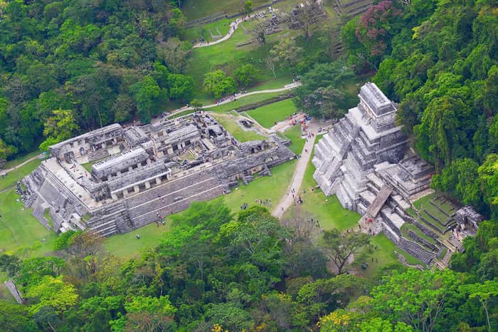
Palenque Archaeological Zone is one of the most interesting archaeological cities in Mexico. To get to know it is to discover the soul of the Mayan world; it is to understand myths, rituals, beliefs, and to admire the majestic architecture of the Mayan people. The pre-Hispanic city and Palenque National Park were inscribed on the World Heritage List in 1987 as one of the main Mayan sites that influenced other settlements in the Usumacinta River basin.
Within a surface of 16 kilometers, there are more than 200 architectural structures and constructions, including the Temple of the Inscriptions, the Great Palace, Temple XI, the temples of La Cruz Foliada, of the Sun, and the Count, as well as the Ball Game. In the surroundings of the archaeological zone, with exuberant vegetation, you will be able to practice trekking and appreciate the flora and fauna, in an extension of more than 1,700 hectares that conform to the Palenque National Park, where different types of birds and mammals like jaguars and howling monkeys live.
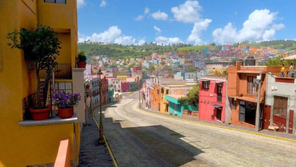
Seven kilometers to the east of the archeological zone and the National Park is located the town of Palenque, which has all the necessary public services, lodging, restaurants, stores, and markets; even and very close to there, you can admire and enjoy the Agua Azul and Misol-Há waterfalls, impressive natural and river attractions.
Cultural Importance
Palenque was, along with Tikal and Calakmul, one of the most powerful cities of the Classic Maya, home to one of the most notable dynasties to which Pakal belongs, whose tomb was discovered in 1952 by archaeologist Alberto Ruz L'Huillier.
Like all the Mayan cities of the Classic Palenque was related to others through commercial networks of exchange or alliances between groups of rulers. The territory was organized based on the existence of city-states, whose centers have been identified by the presence of the so-called glyph emblem, but the basis of this organization: exchange, alliances, and of course war, involves constant mobility of it. However, the hieroglyphic inscriptions not only offer the identification of the site but also give an account of the matrimonial and political alliances and the war situations between cities.
Mayan inscriptions have been widely studied for being one of the first manifestations of writing in Mesoamerica with a logosyllabic alphabet, and for their calendar systems: a cyclic one, as in other parts of Mesoamerica, and a linear one, called long count. Chronology: 500 to 900 A.D. Main chronological location: Classic, 400 to 900 A.D.
Meaning
The archaeological zone takes its name from the neighboring community founded at the end of the 16th century: Santo Domingo de Palenque. The last meaning, also of Spanish origin, means "Estacada" or "Palisade", which is a wooden fence that surrounds a site to protect it. It is possible that the natives preserved in their memory the existence of defensive works in the abandoned pre-Hispanic city.
Meanwhile, the toponym comes from the Chol language, referring to the Otulum stream that means "fortified houses" that crosses the archeological zone. Other names have also been used to refer to the ancient settlement: Na Chán "city of the snakes", Ghochan "head or capital of the snakes", Nacan, Ototiun "house of stone" and Chocan "sculpted snake", among others. The local inhabitants know it with the name of the Otolum stream, whose alternate meaning is "place of the fallen stones". Xhembobel-Moyos, the name of an immediate town, was at one time also used to designate the ruins.
Location
Located in the northwest of the state of Chiapas and located in the heart of a tropical climate jungle, approximately 290 km from the capital city and 220 km from San Cristobal de las Casas. Very close to the city of Palenque is one of the most important archaeological zones of the Mayan world, a destination that should not be missed during the trip to the southern region of the Mexican Republic.
The archaeological zone of Palenque, located only 8km from the city of the same name, has been and is considered the most important ceremonial center of the Mayan culture.
The city of Palenque was founded in 1567 by Friar Pedro Lorenzo de la Nada, who in 1573 gave the Palenque community three bells as a symbol of his town's foundation; of these bells, only the largest is preserved today, in the city's church, and is considered the only testimony of the foundation.
Access
From the city of Tuxtla Gutierrez, it is necessary to take Federal Highway No. 190, towards Ocosingo, and later Federal Highway No. 199, to the town of Palenque. From this last point, a road starts that after seven kilometers lead to the archaeological zone. From Villahermosa, Tabasco, take Federal Highway No. 186, Escárcega-Campeche. At kilometer 114, take the detour that leads to the town of Palenque, where you will travel 38 kilometers on a paved road. The visitor can arrive at the site by public transportation, however, he must walk to the entrance of the site.
Services available in the area
It has a site museum, Service Unit with INAH and Chiapas Brand stores, Library, Auditorium, Children's Workshops, guided tours for school groups, toilets in the Service Unit, at the ticket office, and inside the site.
Schedule
Monday to Sunday from 10 am to 3 pm.
Recommendations
Do not leave the trails, respect areas not open to the public and informative and restrictive signs, and visit the site with comfortable shoes, preferably a pair of walking shoes.
Sources: Turismo Chiapas, INAH