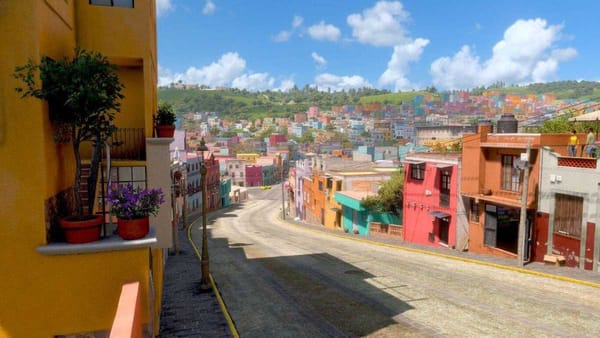
Durango, Mexico: A Paradise for Adventure Lovers and Wild Life Fans
For adrenalin lovers, Durango is the perfect place, as the Sierra Madre Occidental will become your playground. Try to imagine canyons up to 1,400 meters deep, dense valleys and forests, and giant depressions like the Bolsón de Mapimí.

Durango is the perfect place for adrenaline lovers, as the Sierra Madre Occidental will become your playground. Imagine canyons up to 1,400 meters deep, dense valleys and forests, giant depressions like the Bolsón de Mapimí; natural wonders like the Grutas de Rosario, with a depth of more than 500 meters, where stalactite and stalagmite formations can be appreciated... This incites you to live to the extreme!
Do you like strong emotions? You can't miss "El Salto del Agua Llovida", a zip line that passes over a waterfall at an impressive height! Part of the attraction of this activity is that, before jumping into the abyss hanging from a cable, it is necessary to walk through canyons, springs, and gorges. Another option is the "Puente de Ojuela" zip line, which has a length of 330 meters and passes over a ravine at a height of more than 100 meters, a real challenge to your nerves!
Durango is also the ideal land for hunting and fishing lovers since they can find a great variety of hunting ranches, specializing in the breeding of deer, wild boar or wild turkey, and in the case of fishing, a great variety of trout and other species, which allow them to enjoy this sport without putting at risk the balance of the ecosystems.
Blue Canyon
Located in the municipality of Nuevo Ideal in the ejido El Molino and commonly known as the blue canyon because of the springs and the river that crosses a large part of the mountain range, this trail is one of the most impressive in the entire area because of the types of formations that were created by the passage of time in conjunction with the water creating this beautiful canyon. The blue canyon makes you feel like you are inside one of the great canyons of America.
Season
Summer is the perfect season since the small lagoons that are formed on the hike are ideal to feel the coolness of the water and relieve the heat produced by the hike.
Where is it located and how to get there?
Take federal highway number 45 north towards the congregation José Guadalupe Aguilera, taking state highway number 23 until you reach the municipality of Nuevo Ideal, passing the town of La Soledad, 2 kilometers away you will find the entrance to the ejido el Molino, which is where the route begins.
How to walk it and what levels of difficulty?
Walking. Average travel time: 4 to 5 hours depending on the pace of the group. The recommended distance is 5 kilometers since the entire distance of the canyon covers a large part of the sierra, approximately 14 kilometers starting from the Mulas Cave.
The canyon is mostly humid, you go along the side of the river and has a very well-marked trail where it requires a moderate physical condition, good shoes, comfortable clothes to get wet, at least two liters of water, and a local guide to know some cave paintings that are found starting the way in the cave of the Mules.
Trail to Waterfalls
Of the Senderos del Espinazo, this trail offers more scenery and panoramic views and at the same time brings together a bit of all the attractions that Mexiquillo has. When you walk these trails you will not fail to admire the canyons that form the beginning of these waterfalls that run down the Espinazo mountain range, definitely a natural spectacle that you have to explore.
Season
The rainy season -from September to November- is a very good season to take this tour, since the waterfalls can be observed with good flows and excellent waterfalls.
Where is it located and how to get there?
Mexiquillo is located 126 kilometers from the city of Durango and the shortest way to get there is by federal highway number 40 towards Mazatlan, passing through the municipality of El Salto, 31 kilometers away you will see the town in the municipality of Pueblo Nuevo.
How to get there and what levels of difficulty?
Walking. Average travel time - 2 hours at a moderate pace. Most of the trail is very well marked and all the time you will be able to see references to guide you on your walk. Time is a factor to consider, and you should carry at least two liters of water.
Mountain biking. Average travel time: 45 minutes at a moderate pace. Ideal to practice it in the family because it has wide roads and is relatively very simple to ride. Before reaching the Paso Resbaloso Waterfall, there is a narrow road where you need to get off the bike to cross the river or pose for a photo at the waterfall.
Horseback riding. Average travel time: 1.5 hours. A horseback ride is an excellent option to get to know this tour and admire each of the waterfalls in case you are not in adequate physical condition to walk. The riding time is relatively short, so you are not likely to feel any discomfort from sitting on the horse.
The Otinapa Forest
In the western region of the sierra of the state of Durango is a small and very picturesque town. It is Otinapa, a place where the forest, cabins, viewpoints, bridges, and adventure activities come together to offer a destination that will make you feel that rest and fun can be switched.
Season
Summer is the perfect season to visit Otinapa. We recommend you to go with your family since the complex of cabins located in this place offers many activities for young and old to have fun. In addition, the facilities are very comfortable to rest in and are easily accessible from the city of Durango.
Recommended length of stay
Definitely 3 to 4 days is the recommended time to visit each of its attractions, disconnect a little from the hustle and bustle of the city, and relax with your family or your favorite person.
Where is it located and how to get there?
Otinapa is located 53 kilometers from the city of Durango and the option to get there is by federal highway number 40 towards Mazatlan, at kilometer 41 you will find the junction that will take you to the town. If you travel by bus, the vans to the town of Orinapa are the option to travel. It departs once a day until it is full and its departure point is the former Cuartel Juarez, in the Plaza Baca Ortiz, on Isauro Venzor and Pasteour streets.
What you have to enjoy
Otinapa Plains. This circuit is one of the most impressive scenic trails in the entire state of Durango. It is part of an embankment built at the beginning of the century where you will cross ravines, bridges, forests, and special field meadows to take the picture of your life.
Activities at the cabin complex. Approximate time of activities agenda per day 6 hours. The cabin resorts know and know how to take care of their visitors. Many of them have the infrastructure for family fun, such as zip lines, interpretive trails, lagoons for kayaking in the middle of the forest, among many other options or games that can be done around a campfire, completely away from any electronic media.
The Otinapa jump. Stay and bungee jumping time 2 hours. This activity is relatively new in this area and is simply one of the best adventure experiences in the state of Durango, as it is part of the Otinapa railroad bridge, an icon of the area, and holds the record for the highest free fall by bungee jump in Latin America.
How to walk it and what levels of difficulty?
Walking. Average travel time: 3:30 hours.
All-terrain cars. Average travel time: 1 hour.
Mountain biking. Average travel time: 1:30 hours.
Horseback riding. Average travel time - 2:30 hours.
The waterfall in Sierra de Nayar, Durango
The experience begins when you enter the road to Molinillos and lasts until you reach one of the most spectacular waterfalls that exist in Mexico; El salto del agua llovida is the name given to this place where the combination of sky, light, forest, water, rainbows, and sensations are simply perfect.
Take 5 minutes to admire the whole landscape and you will discover that the beauty of this place is in those small details that form the whole panorama you see around you. Feel the breeze that rises and makes you see that the water rises as it falls into the ravine with the lullaby of a crash of water that breaks between the stones at the bottom of the canyon.
Season
It is important to mention that this waterfall has water every month. The months from August to November are the rainy months where it shows its maximum splendor and the consequence of the green of all the vegetation is impressive. A recommended length of stay, taking advantage of the activities in the area, especially if you only go to the waterfall, can be 4 days.
Where is it located and how to get there?
If you leave the city of Durango you must take state highway number 40 heading southwest to pass through the town of El Soldado, El Tecuan National Park, and arrive at Navios. There you will find the junction to the Nayar mountain range, as a reference you will see the Kary restaurant.
What you should enjoy
Cabins area. Recommended length of stay: 2 nights. The nights in this part of the sierra are extraordinary and the whole area has excellent tourist infrastructure to spend a few days in the heart of the sierra of Durango.
Camping. Recommended length of stay: 2 nights. With a large extension of roads and trails that start from Molinillos and cover a large part of the sierra, with very well-equipped shelters that make connections between the trails and trails to the Molinillos waterfall. For better orientation and trail detail it is important to hire a specialized guide from the city of Durango or obtain maps from the lodge operators.
Mountain biking. A very interesting plan is to arrive directly with the cabin operators to check-in, in and then enjoy the afternoon by mountain biking to the waterfall.
Night Photography. You will have a whole night to practice, average time: 3 hours. The starry sky is one of the spectacles of this area and you can capture it with your camera in the comfort of a cabin, accompanied by a good coffee and your favorite person.
How to ride it and what levels of difficulty?
Mountain biking. Average travel time: 6 hours.
Estación Patos ("Ducks Station")
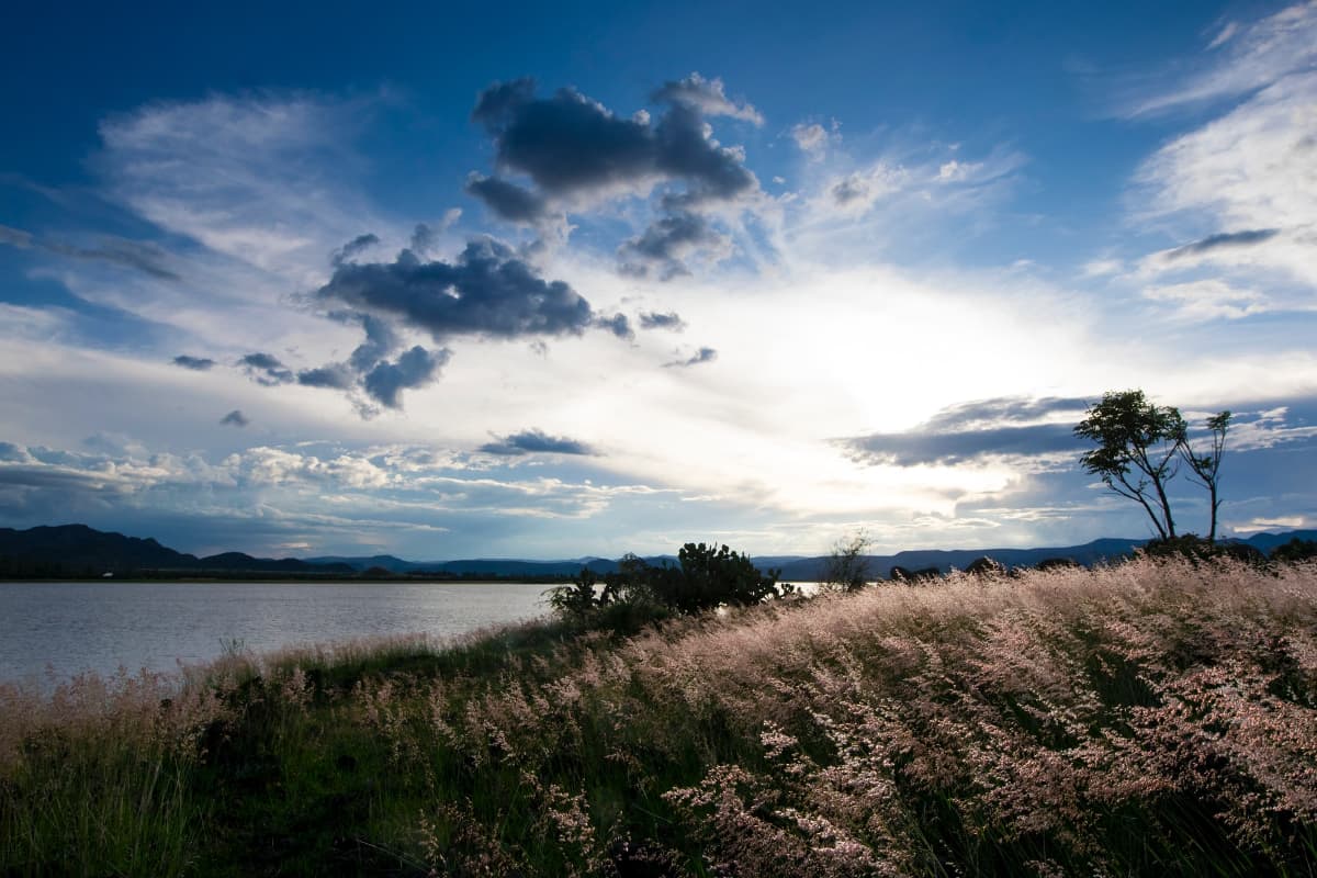
Now known as the municipality of Nuevo Ideal, this area surrounded by hills in the middle of a flat plain has two reservoirs; Laguna de Santiaguillo and Persa el Tejamen, which due to their proximity offer an experience of contrasts and unique activities for people who enjoy a good sunset as well as for birdwatchers and landscape photography.
Season
Estación Patos can be enjoyed in two seasons depending on the purpose of the trip; in the summer you have the opportunity to combine landscape photography with a dip in its waters as well as fishing, kayaking, or paddleboarding. The name of Patos station has an origin and it is especially for the winter season and the accumulation of different types of resident bird species and especially the ducks that provide a unique spectacle of the year, combining the sunsets and clear dark that only gives you the winter sun.
Where is it located and how to get there?
Santiaguillo Lagoon. Take federal highway number 45 north towards Ciudad Canatlán, taking the junction of state highway number 23 towards the municipality of Nuevo Ideal. Arriving at the congregation of Guatimape, you take the rural road until you reach Fuente del Llano Santiaguillo.
Tejamen Dam. Arriving at the urban area of the municipality of Nuevo Ideal you take the rural road to the town of Tejamen, which is only 20 minutes away.
How to visit and recommendations?
Photography and bird watching.
Santiaguillo Lagoon. Approximate time of stay 3 hours. The recommendation is first to visit the Santiaguillo Lagoon which is located in one of the most interesting valleys of the state of Durango called Guatimapé Valley these plains and their dark sunrise glades are its main attraction and from there comes the activation of the different types of resident bird species as well as native to the region. A good photograph of the sunrise inside the plains that cover the dam is a unique spectacle of the lagoon.
Tejamen Dam. Approximate time of stay 3 hours. Already in the mountains of Coneto de Comorfort within the Tejamen congregation is a very old mining town where time and the stories of gold come together in a reservoir where its main attraction is the landscape as it is surrounded by forested mountains and rock monoliths in the middle of the water forming rocky islands. Here the alternate activities in summer complement the day. This is an ideal place to spend the afternoon or even camping.
Lava Labyrinth
Billions of years ago, the mountainous structures of the Sierra Madre Oriental. In the process, they created clusters of lava that over the years became petrified and formed one of the most impressive natural settings in Mexico, known today as the Stone Garden. Imagine stones more than 6 meters high, together, on a land of more than 30 hectares, to form the Labyrinth of Lava in the forest of the Sierra de Durango, located in Mexiquillo, 126 kilometers from the city. You will simply want to see it.
Season
Any season of the year is good to visit the labyrinth, even if there are rainy conditions. We recommend touring it by mountain bike because the stone provides an excellent grip, there is also the option of horseback riding or walking to get to know it.
Where is it located and how to get there?
Mexiquillo is located 126 kilometers from the city of Durango and the shortest way to get there is by federal highway number 40 towards Mazatlan, passing through the municipality of El Salto, 31 kilometers away you will see the town in the municipality of Pueblo Nuevo.
How to walk it and what levels of difficulty?
Walking. Average travel time: 1.5 hours at a moderate pace. Due to the proximity of the labyrinth to the cabin area, it is an ideal destination to visit on foot, and it does not require a great physical condition to do so. The lava labyrinth area has spaces set up for eating or preparing food on grills, and there are also ecological restrooms distributed throughout the park.
Mountain biking. Average travel time: 45 minutes. The difficulty varies depending on the speed and the type of road you choose in each zone of the labyrinth since some ascents or descents require technical expertise to cross them.
Horseback riding. Average travel time: 1 hour. If you are traveling with your family, we recommend choosing a horseback ride to get to know the place. In addition to making the ride fun for children, the experience is very relaxing, as it allows you to enjoy the scenery without any effort.
Trip to the Zone of Silence, Bolsón de Mapimí
One of the natural spectacles with the ability to leave you speechless is the Leonids star shower in the Zone of Silence. Just being in a place where there is no electric light, turning to the sky and seeing an infinity of stars covering the firmament, is something unique and beyond words. On this occasion we want to share with you a travel proposal to enjoy this spectacle, you only need a good jacket and an internal "yes" to leave your comfort zone.
Season
November is the month where you will be able to see the Leonids star shower. This star shower is one of the most colorful and in a place so far away from the city you will be able to appreciate it in all its splendor. It is worth the trip because the sky is covered with stars everywhere you look and there will come a time when you will surely not need the light of your lamp to guide you, you will feel like the first settlers of the world! If you visit the area in this season, you must bring clothes to protect you from the cold because at night temperatures drop to 0° and more.
Where is it located and how to get there?
Leaving Monterrey, travel on the highway to Saltillo and continue on the road to Torreon towards the city of Jimenez, Chihuahua. You have two options to get there, toll road or free highway; if you travel on the first one, take the detour towards the ejido La Flor at approximately kilometer 127, and if you travel on the second one, take the detour at the town of Ceballos. Travel time is 6 hours, depending on road conditions.
Activities
With these landscapes, night photography is the activity to do in this area.
Prepare the campsite. You can choose between camping or sleeping in rooms. The camping option is much more economical and also adds that adventure flavor to the occasion, but be prepared to feel the intense cold at night; a 4-season tent will ease your sorrows. The rooms are practically new and are excellent for people with physical aches and pains that might prevent them from sleeping on the floor.
Full belly, happy photographer. Nothing like a good stew, accompanied by handmade corn tortillas and a pot of coffee to fill the belly and start all the day's activities. The ejidatarias (communal land areas) of La Flor prepare the food on the spot: we can't describe to you the taste of the fresh cheese or the flour tortillas or the chocolate shells because it simply... makes our mouths water!
Sunset hike. Start by exploring the trails allowed inside the Bolsón de Mapimí. One of the most peaceful and doable hikes starts from the campground area towards a hill that stands out in the middle of the plain. On the way you will find some of the great wealth that the Zona del Silencio has in terms of flora and fauna, so be very careful with every step! At the top the spectacle is marvelous: the sky is painted in every possible shade of orange, yellow, red, purple, and pink, with the sun in the background hiding on the horizon. Take the opportunity to take out your camera and practice sunset photography, or just sit and contemplate and feel the peace of the landscape.
Marvel at it. If you thought that's all, just wait, because the sunset is just an appetizer. As the sun sets, the sky darkens and the first stars begin to emerge. In the first few minutes, the sky will be as starry as you can see in a metropolis, and in the first hours of the night, you will begin to glimpse the clouds of stars that cover the entire sky. Wherever you look, there will be stars, and in a coincidence of your gaze and the world, you will be able to see a shooting star.
Have fun: Flashlight painting. You can take advantage of the early evening hours to practice flashlight painting. This activity requires making patterns with LED lights in front of a camera. The exposure time is longer, so the light trail will be engraved in the image. You can invite your family or friends to create a light composition, the results are a lot of fun.
Mythology and constellations. Nothing like imitating the first human civilizations in their contemplation of the sky and the stars. From this observation comes the classification of stars as constellations and their names reflect attributes of human beings towards a distant reality that in ancient times seemed impossible to reach.
Night photography all night long. Be prepared with your camera, a tripod, and a good jacket to take pictures all night long. Photos of stars require a longer exposure to capture their movement; although it takes time and attitude to stay awake, the results are well worth it.
Museums. Inside the communal grounds, there is a museum with an explanation of the flora and fauna of the region. You will also find curious facts about the Zona del Silencio and the surrounding ejidos. A little bit of history to enrich our knowledge of this part of the country.
Mexiquillo to Miradores Route
One of the most historic roads in the country is the Miradores route. The free road from Durango to Mazatlan, starting from the area of Mexiquillo, is imposing in every way since most of the way you will notice that the road crosses the entire slope of the mountains between the deepest ravines and canyons of Mexico.
The first thing to do is to get to Mexiquillo, which is located 126 kilometers from the city of Durango and the shortest way to get there is by federal highway number 40 towards Mazatlan, passing through the municipality of El Salto, 31 kilometers away you will see the town called La Ciudad, located in the municipality of Pueblo Nuevo.
One of the most adventurous and historic routes. Starting at Mexiquillo, on the Durango-Mazatlan free highway, the imposing nature reigns throughout the journey through the deepest ravines and canyons of Mexico, along the slopes of the Sierra Madre Occidental.
Where is it located and how to get there?
The first thing to do is to get to Mexiquillo, 148 km from Durango's capital. This is the starting point for 20 kilometers of adventure on Federal Highway No. 40 (Libre Durango-Mazatlán) until you reach the majestic "Espinazo del Diablo" (Devil's Backbone).
Season
It is advisable to make the trip during the low vacation season or in summer. The clear weather and the road without traffic allow you to enjoy the endless scenery at your leisure.
How to get there and recommendations
23.8 kilometers from Mexiquillo. Average travel time: 4 hours.
Vehicle. Special for a trip by car and recommended to take the whole family. It is necessary that the vehicle is in excellent condition, as well as to have all the precautions and attention to travel, especially in these kilometers of the road. The road has two viewpoints and in some stretches, there are special spaces on its sides to park the vehicle without any danger and get out to take a picture of the landscape of the ravines of the Sierra de Durango.
Buenos Aires Viewpoint. Known as the Puerto de Buenos Aires and located 11 kilometers from Mexiquillo, this viewpoint has a special view of the canyons of the Sierra de Durango. If you pay attention you will notice three peaks in the sierra that, according to the locals, are three friars walking down the mountain.
El Espinazo's viewpoint. Originally this part of the road emerged from a wagon pass where you could cross the mountain range between a space of 4 to 5 meters over one of the most dangerous and high slopes of the whole country, thus giving rise to its name, El Espinazo del Diablo (The Devil's Backbone). It is currently one of the best viewpoints of the entire highway system that exists in the country, from where you can contemplate the two sides of the road and the ravines with one of the deepest falls in all of Mexico.
Puentecillas: between bridges and landscapes
A destination for those who enjoy landscapes is Puentecillas, Durango. The area has one of the best viewpoints of the mountain range that represents the Sierra de Durango and is characterized by its wooded roads, impressive interpretive trails, lagoons in the middle of canyons completely covered by trees -some of them endemic- cabins, and camping areas with a unique view in the country.
Season
In the season from October to March, the combination of forest and mountain provides a very special experience thanks to its scenery that combines with the chiaroscuro of the sun, between the greens and oranges characteristic of autumn. The weather is in your favor since you can walk comfortably with a light jacket, and in the evenings you can take advantage of the warmth of the campfire or the company of your partner to mitigate the cold.
Recommended length of stay
We recommend planning a 3 to a 4-day trip to explore, navigate, admire and rest in this valley of forest and reservoirs in the state of Durango.
Where is it located and how to get there?
The area of Puentecillas is located 126 kilometers from the city of Durango and the way to get there is by federal highway number 40 towards Mazatlan, 16 kilometers past the municipality of El Salto you will find the congregation of Las Adjuntas where the dirt road junction to get to this place is located. If you are traveling by bus, it is advisable to take a route to the El Salto bus terminal and then take a cab or fish boat to the Puentecillas area.
Santa Barbara Trail. Travel time: 4 to 5 hours depending on the pace of the group. It is a trail made entirely of wood and has bridges and stairs in almost the entire route, you will also find viewpoints, and waterfalls, and the most interesting thing is that it is located in a spruce tree forest, unique in Mexico. It is a trail for the whole family, very easy to walk, and with an extension of 7 kilometers starting from the lagoon.
The trail to Miradores (Viewpoints). Travel time: 3 hours. This is a gap that reaches the canyon, where you can find one of the best viewpoints in Durango and see much of the mountains and mountain ranges. This trail is 1.5 kilometers from the lagoon and can be done on foot or by mountain bike.
The Regatta of the Clouds. Recommended time: 3 hours. Any time is good for sailing in the Puentecillas Lagoon, but we recommend doing it very early in the morning. At this time of day, the water becomes a mirror that gives off steam, and the sun's rays filter through the pines that surround the lagoon; it is simply a landscape to remember for a lifetime. Kayak paddling is an activity for everyone and has no cost if you are staying in the cabins. Rental to the general public varies.
Sport Fishing. Recommended time: 4 hours (or the patience and time you like to invest in fishing). In the lagoon, you can find carp, mojarra, and wolf fish. You must bring your equipment since the cabins do not have a rental service. It is recommended that the bass fishing is sport fishing, doing the exercise of catch and release.
Landscape or nature photography. Recommended time: 3 hours. Regardless of the weather conditions, Puentecillas will always be a great destination to practice landscape photography; night photography to capture the stars and wildlife photography since there are different types of birds that you can capture with a good telephoto.
Cheese Route
The Mennonite region of the Durango area is a place full of contrasts and valleys where the clear dark afternoons provide a very peculiar nostalgia for the area. The work is reflected in every detail, from their plots to the interior of their homes, which makes it a cultural destination within the state of Durango.
Among all the variety of products derived from milk in which each of the families participates by contributing their daily production, the specialty is the production of Chihuahua cheese. It is a semi-soft cheese made in Mexico from pasteurized or raw cow's milk.
Season
This is a destination open all year round, a difference, if you visit it during the rainy season, is the green plains that you will be able to contemplate on the road when it rains.
Where is it located and how to get there?
It is located in the municipality of Nuevo Ideal, before reaching the urban area of the municipality.
The tour
Breakfast. Restaurant. Estimated time: 40 minutes. It all starts with a good breakfast and the perfect opportunity to meet the guides and the people who will take us to each of the destinations. Remember to hire one of the municipal or state guides who will help you open each of the doors of the Mennonite destination.
Shopping. Mennonite bazaars and clothing. Estimated time: 3 hours. One of the things we can admire about this culture is the self-sufficiency of the goods they can build themselves and the ease with which they can open their doors to buy or sell. You never know what you might find, from a chair built in Russia at the beginning of the last century to a tractor-trailer. Each settlement has several stores open to the public where you can buy unique items in the country, which denote the style of the Mennonites.
Cheese tour. Travel time: 3 hours. One of the most important activities in the Mennonite community is the elaboration and production of cheese. Although some families continue to preserve more artisanal methods, many others have modernized using international machinery and processes for cheese making. It is interesting to see the transformation of the product from the time it is obtained from the cow to the end on the counter shelf.
Afternoons at the Patos Station. Recommended time to practice it: 2 hours. The municipality of Nuevo Ideal, as well as other Mennonite settlements in the surroundings, has a natural view where you can appreciate sunrises and sunsets with rural landscapes and mountain ranges worthy of a good photograph.
Dinner with a Mennonite family. Recommended time: 2 hours. If you have the opportunity, take advantage of the hospitality of a Mennonite family to have breakfast/lunch/dinner. This is a unique opportunity to get to know people from different cultures. You can take advantage of this opportunity and ask for advice on activities to do or places to visit, and they may even give you medicinal advice.
Backbone Trail
Among caverns, forests and one of the best and most impressive canyons in Mexico starts a path that was once an embankment for one of the first railroads that crossed the mountains of Durango; now, it is one of the best trails to explore and get to know our country. Its name comes from the well-known Espinazo del Diablo (Devil's Backbone) since it is part of the sierra and crosses two rivers that in turn form two spectacular waterfalls.
Season
We recommend a visit after the rainy and winter season since the tour has two spots where you will see waterfalls overflowing with water and a complete panoramic view of the canyons, much greener, in the Mexiquillo area.
Where is it located and how to get there?
Mexiquillo is located 126 kilometers from the city of Durango and the shortest way to get there is by federal highway number 40 towards Mazatlan, passing through the municipality of El Salto, 31 kilometers away, you will find the town of La Ciudad in the municipality of Pueblo Nuevo.
How do go through it and what difficulty levels?
Walking. Average travel time: 4 to 5 hours depending on the pace of the group, at a moderate pace. It requires moderate physical condition, good footwear, at least two liters of water, a raincoat, a lamp, and preferably a local guide to show you every detail that otherwise you could hardly appreciate. You will learn more about the nature of the place while walking. Cost per guide: 100 pesos per person. You can hire this service with the administration staff of the Mexiquillo cabins.
All-terrain cars. Average travel time: 1 hour. You will need a Razor or motor vehicle with advanced equipment to cover complicated roads over long distances. If you decide to travel in a vehicle, it is important to consider that a large part of the road crosses one side of the canyon with ravines and gorges that require all your experience to be able to cross them.
Mountain biking. Average ride time: 2 hours at a moderate pace. A double suspension bike is highly recommended. You need moderate to good physical condition, a repair kit with a change of tubes, light or LED lighting, and at least 3 liters of water. The trails and the slopes, both downhill and uphill, are what make this trail a very fun mountain bike ride. At no time along the way will you feel bored or feel that it is easy to ride.
Sources: Government of the State of Durango