Disasters: Floods in Mexico during the Rainy Season
Floods caused by phenomena known as severe storms, incipient tornadoes, hailstorms, or hurricanes occur every year in some parts of Mexico during the rainy season. Get to know more.

Every year, somewhere in the Mexican territory, during the rainy season there are floods caused by phenomena known as severe storms, incipient tornadoes, hailstorms, or hurricanes. All of these come from one or several supercells called cumulonimbus, which are cauliflower-shaped, with a base of about 25 km in diameter and a large vertical development of 12.5 km or more.
Floods have been classified into two types. The first is that which occurs in coastal areas when an intense storm or hurricane raises the sea level by one meter or more and causes sudden flooding of low-lying coastal regions, this phenomenon is called storm surge. The second type occurs when a large amount of water flows into a river causing its level to rise and break the bank; this phenomenon is produced by heavy rains or thaws.
Floods can often be disastrous, as was the case when a hurricane hit eastern Pakistan in November 1970, killing 300,000 people. But they can also be beneficial, such as the Nile floods that have annually irrigated and fertilized the soil of Egypt for thousands of years.
Storm surges
Storm surges are abnormal rises in sea level caused by wind forces and pressure from a hurricane or extratropical cyclone. The sea level anomaly is measured by the tide gauge and refers to the difference between the observed minus the predicted level. Storm surges produce the greatest damage when their effect coincides with that of the normal high tide.
Many areas of intense low pressure that pass along a coastline raise sea level by one meter or more; rises greater than two meters are rare and generally disastrous. Although there are no accurate records of sea-level rise, the best-documented upwelling is the 667 m surge produced by Hurricane Camille (1969) off the Gulf of Mexico. There are unverified reports of some estimated up to 12 m produced by some of the 1737 cyclones in Calcutta, India. Many of the most spectacular storm surges have occurred during hurricanes.
Atmospheric conditions or weather can affect sea levels in different ways. One well-known effect is the so-called inverted barometer effect which can be explained as follows: if you were to build a giant tube and put it over the ocean, drawing air out of the tube, the water will rise exactly as it does in a barometer. This is what happens in a hurricane, except that the hurricane does not need any giant tube to keep the pressure down.
It has been found that for every hundred pascals (Hpa) that the air pressure drops, the water rises one centimeter. This is why many hurricanes that have a pressure that is 50 to 753 Hpa lower than the surrounding area will cause the effect of the inverted barometer to raise the sea level by only 50 to 75 cm. Even in the most intense hurricanes, only 1.5 m of sea level would rise due to this effect.
Other phenomena must be added to the effect of the inverted barometer to produce the most spectacular sea level rises. Every intense storm has strong winds. When the winds blow against a coastline they pile up the water in front of the beach; conversely, when the wind blows against the sea, it will drag the water away from the beach lowering its level. This effect of the wind is enhanced by the depth of the water, i.e., the shallower the water, the greater the height the wave can reach.
Another factor that can add to sea-level rise is the so-called resonance effect. There are times when a storm moves along a coastline, with the wind blowing away from the beach but, once the center of the storm passes, the wind direction reverses. So, initially, the water will be blown away from the beach, but as the center of the storm is passing, the wind will stop blowing and the water will begin to back up making a "splashing" noise. As the water turns back on itself, the wind suddenly starts blowing towards the beach giving the water an extra push. In this way, it will rise higher than if a steady wind had been blowing towards the beach all the time.
The resonance effect has caused disasters along the Gulf Coast and has also caused flooding around Lakes Okeechobee in Florida and Ponchartrain in Louisiana.
There is another case of the resonance effect that is a bit more complex but real: the mound of water increased by the effect of the inverted barometer can act just like a large ocean wave if the low-pressure area suddenly disappears. This wave would take a long trip outward, just like the waves emanating from the place where rock falls into the water.
Now, if the low-pressure area moves, the same effect occurs and the raised mound begins to travel outward; resonance will occur if the low-pressure area moves as fast as the wave. This only happens in shallow water and can produce serious consequences, for example, the flooding that occurs at the mouth of the Bay of Bengal along the coasts of India and Bangladesh (East Pakistan).
Overflowing of rivers
There are a variety of conditions that can cause a river to overflow. Some of them are excessive rainfall, snowmelt, some obstructions such as ice jamming or debris, and also the collapse of a dam. The worst floods occur when some of these factors combine; for example when torrential spring rains help to melt the snow and the water level rises to cause a dam to collapse.
Soil conditions are critical and largely determine the severity of a flood. Suppose the soil is saturated with water from previous rains or hailstorms that make it impermeable. In that case, flooding tends to be more serious simply because the new rain cannot percolate through the soil and will flow directly into the river. Moderately dry soils can absorb some of the rainwater and thus reduce flooding. Paradoxically, extremely dry soils can become hard as concrete and therefore relatively impermeable.
During the winter, in the middle and high latitudes, much precipitation falls as snow accumulates on the ground, which will melt in the spring causing the rivers to reach their highest level of the year. Thus, the possibility of flooding after a winter that has been especially cold and with much snowfall is latent. The dangers of flooding are also increased in situations where the ice flowing down the river becomes jammed, damming the flow of water; this raises the level of the river causing the ice wall to break and the water to run down with great intensity, making the risk of flooding greater.
Another effect that influences the risk of flooding is the ruggedness of the terrain. During downpours in mountainous regions, mudflows emerge containing large amounts of mud, sand, pebbles, boulders, and huge boulders weighing several tons. In many cases, these streams arise as a result of snowmelt in the mountains. In times of downpours, or when snowmelt is strong, the beds of small mountain rivers, usually dry or almost dry, become powerful torrents of stones and mud. In general, these torrents have an immense destructive force. The fragmented material is transported to the adjacent flood plains or cities, as happened during the passage of Hurricane Paulina along the coasts of Oaxaca and Guerrero in 1997.
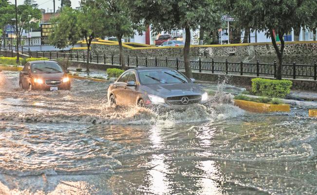
Floods in cities occur when it rains with great intensity, which can be combined with the topography of the terrain and poor drainage design, causing economic losses in landslides, victims, and road problems.
Flood mitigation
In general, meteorological disasters are the most frequent and the ones that have caused the greatest material and human losses in the history of Mexico. It is estimated that floods in different regions of the country, in the last 40 years, have affected some 18 million Mexicans. In terms of risk, approximately 12% of the Mexican population is exposed to hurricanes in areas where the recurrence period of this meteorological phenomenon is 2 to 4 years.
At present, several institutions of higher education and research, such as UNAM, focus their attention on the study of disasters of natural, anthropic, or technological origin, since a man in his growth and accelerated socio-economic development has caused the rupture of the natural balance and, in addition, has facilitated the destructive action of endogenous and exogenous phenomena, with the consequent catastrophes manifested at planetary, regional and local scales.
One of the contemporary scientific approaches is the mapping of the phenomena that cause disasters, which is expressed by a series of specific maps such as the Risk Atlas, which works of vital importance before, during, and after the occurrence of an event of this nature.
How are risk maps used? The flood map is used for zoning land use, in which the areas most prone to flooding are designated for recreational use and not for urban construction. Soil erosion maps are used in agricultural development projects and also to estimate forestry development needs; in some places, such as California, USA, they are used as part of building regulations, which restrict high-density housing in areas susceptible to ground movements and landslides.
For this reason, it is necessary to learn to live with the risk of floods by promoting the training of the population and encouraging self-care and self-preparation is a valid way to mitigate the effects that may occur; in other words, it is necessary to form a culture of civil protection. Since the country is immersed in a modernization process, it is necessary and very important that along with education, construction of facilities, and improvement of productive, commercial, and service processes, there is also a modernization of the mentality.
In this process of awareness-raising and formation of new attitudes, foresighted behavior will find its place and a culture of civil protection will be achieved since a change of this nature will not happen either by decree or by obligation. It must happen by free, spontaneous, and voluntary choice, involving the punctual observation of the minimum rules of coexistence and the identification and observance of personal, professional, and social ethics.
By Francisco Villicaña Cruz, Source: Correo del Maestro No. 31