When and where will Tropical Storm Karl make landfall?

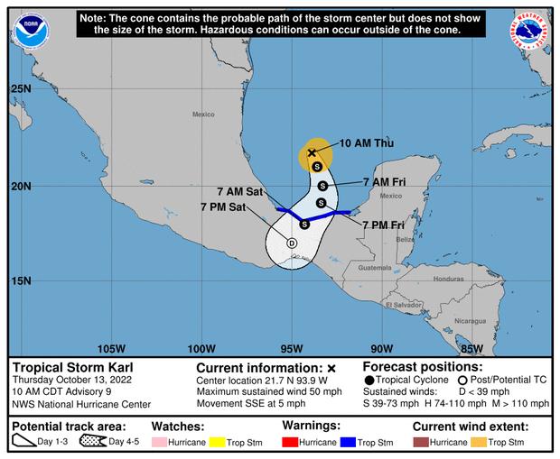
On its projected path, Tropical Storm Karl will make landfall around the coasts of the states of Tabasco or Veracruz late Friday night or early Saturday.

When and where will Tropical Storm Karl make landfall?
The trajectory of tropical storm Karl.

Mexico called on state and municipal authorities and the population of several states in the eastern part of the country to take extreme precautionary measures to prevent damage to people's lives in the face of the development of tropical storm Karl.

The National Meteorological Service (SMN) said this Thursday that extraordinary rains (greater than 250 mm) will cause extraordinary rains this Friday in the northwest of Chiapas, the west of Tabasco, and the south of Veracruz, as well as torrential rains in Oaxaca, informed the National Meteorological Service (SMN). The SMN said in a statement that Karl "will get close to the southern coast of Veracruz and western Tabasco" tomorrow.

This will cause heavy rains (more than 250 mm) in the northwest of Chiapas, the western part of Tabasco, and the southern part of Veracruz. It will also cause torrential rains (150 to 250 mm) in parts of Oaxaca, very strong rains in Campeche and Puebla, and strong rains in parts of Yucatan.

"Due to the precipitation, which could be with electrical discharges, strong winds, and possible hailstorms, landslides could occur, increase in the levels of rivers and streams, overflows and floods in low areas of the mentioned states," said the Meteorological Service of Mexico.

In addition, it called on the population of these states to follow the indications of state, municipal, and civil protection authorities and asked maritime navigation in the vicinity of the system to take extreme precautions due to strong winds and waves in coastal areas.

Tropical Storm Karl will make landfall where?

According to the report, "the cyclone center" is 250 kilometers (km) north of Frontera, Tabasco, and 320 kilometers (km) north-northeast of Coatzacoalcos, Veracruz, at 19.00 local time (00.00 GMT Friday).

It also has sustained winds of up to 75 km/h, gusts of up to 95 km/h, and moves 11 km/h to the south-southeast.

The National Hurricane Center in Miami and the SMN work together to keep a tropical storm watch in place from Alvarado, Veracruz, to Ciudad del Carmen, Campeche.

On the other hand, the institution pointed out that a low-pressure channel over western, central, and southern Mexico, in combination with the entrance of humidity from the Pacific Ocean, will generate intervals of showers in the states of Colima, Guerrero, Jalisco, Michoacán, Quintana Roo, San Luis Potosí, and Tamaulipas.

On Thursday, the U.S. National Hurricane Center (NHC) reported that it expects the tropical storm to turn south or south-southwest toward the Bay of Campeche on Friday, a movement that should continue until the early hours of Saturday.

On the forecast track, the center of Karl should reach the coast of Tabasco or Veracruz states Friday night or early Saturday.