The cave paintings of the Sierra de San Francisco, Baja California Sur
The arid and rugged sierras of the Baja California peninsula have preserved testimonies of human history that neither time, earthquakes nor hurricanes have been able to erase. Travel back in time through the rock art of Baja California Sur.

Baja California's arid and rugged sierras have preserved testimonies of human history that neither time, earthquakes, nor hurricanes have been able to erase. Take a journey into the past through the rock art of Baja California Sur. The pictorial manifestations of this biocultural landscape, inscribed in the Gran Mural tradition, are due to multiple groups of hunter-gatherers and nomadic fishermen who in their constant movement through the desert, the sea, and the mountains, used the rock shelters to preserve their memory, represent their thoughts and configure their identity.
The Sierra de San Francisco is located south of the borderline that separates the Mexican states of Baja California and Baja California Sur. The rock art of the Sierra de San Francisco is considered one of the largest scale rock painting traditions in the world. Its style has been called "Great Mural", a term coined for its monumentality in the 1970s by American photographer Harry Crosby who published the book The Rock Paintings of Baja California: Discovering the Great Murals of an Unknown People. The missionaries knew these works, the Jesuit Francisco Javier Clavijero described them in Historia de la Antigua o Baja California (History of Ancient or Baja California, 1789):
"These paintings, although crude, clearly represent the objects and the colors that were used for them, it can be clearly seen that they were taken from the mineral earth that is in the surroundings of the volcano of the Virgins. What most admired the missionaries was that those colors had remained on the stone for so many centuries without being damaged by air or water.
Not being those paintings and dresses typical of the savage and brutalized nations that inhabited California when the Spaniards arrived there, they undoubtedly belong to another ancient nation, although we do not know which one it was. The Californians unanimously affirm that it was a gigantic nation that came from the North".
The first settlements in the region date back 10,000 years, the paintings would have been made between 1,100 B.C. and 1,300 A.D. according to the dates obtained in the deposits associated with the rock shelters. It is thought that their settlers were ancestors of the cochimíes that occupied the region until their extinction in the XIX century as a consequence of the Spanish conquest; nevertheless, the cochimíes have denied knowing their origins, and they attributed it to the work of an old race of giants, already disappeared, coming from the north.
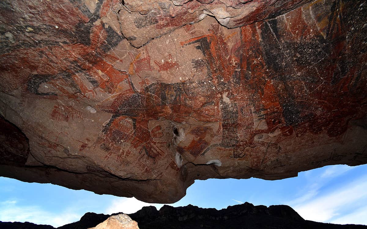
The rock art is distributed in hundreds of rocky shelters of the intermontane canyons, for its difficult access and the dry climate of the region the state of conservation is very good. The style is essentially realistic, dominating the human figures and fauna designed in red, black, white, and yellow. On December 11, 1993, the World Heritage Committee of UNESCO granted the distinction of World Heritage to this extraordinary collection of cave paintings, surprising for the quality, dimension, variety, originality, and polychromy of its representations.
Sierra de San Francisco
It is located towards the central part of the Baja California Peninsula, in the region known as Aridoamerica, it consists of a group of cave paintings belonging to the Great Mural style. The caves that house sets of paintings are: La Pintada, Las Flechas, La Música, La Soledad, Boca San Julio, Cuesta Palmarito and El Ratón. The zone of the great murals, which covers 12,000 square kilometers of the central region of the peninsula, has its epicenter in the Sierra de San Francisco.
National Institute of Anthropology and History (INAH) has delimited the archaeological zone and it is necessary to have an authorized guide to visit any of the sites that are open to the public. The most accessible site in the Sierra de San Francisco is the Cueva del Ratón, 37 km from the transpeninsular highway, on a dirt road that leads to San Francisco de la Sierra, a small village nestled in the heart of these mountains. From there you can make trips to visit other sites with rock art, such as La Cueva Pintada, Cueva de las Flechas or Boca de San Julio.
To make these visits it is necessary to go by mule accompanied by a guide and camp in the canyons. The several hundred people who do it every year make a trip through a surprising and abrupt landscape that, in addition to offering natural beauty in abundance, offers the opportunity to be in a huge open-air museum dedicated to prehistoric art. Other places where examples of rock art can be found are the Cueva de la Serpiente and the Cueva de la Candelaria in the Sierra de San Francisco, as well as the Cueva de los Venados and the Cueva de San Borjitas in the Sierra de Guadalupe.
The rock art of the Sierra de San Francisco represents a cultural tradition that developed over millennia; the dating of the paintings has given an antiquity of at least 7500 years B.P. When the indigenous population was eliminated, the sites remained intact until the end of the 19th century, when the mountains were repopulated. The integrity of the rupestrian sites and their surroundings have maintained a very high percentage of their original conditions due to circumstances related to the isolation and low population density that prevails in the region. The toponym of this Sierra is related to the name of a Pueblo de Visita, a small temporary chapel founded in the highest part of these mountains that were under the jurisdiction of the Jesuit Mission of San Ignacio Kadakamaang.
It is necessary to arrive in San Francisco de la Sierra by the dirt road that begins in the section of the transpeninsular highway (federal number 1) that unites the population of San Ignacio with that of Vizcaíno (approximately to 46.7 kilometers of the deviation, that leads to San Ignacio). It is necessary to go to Santa Teresa Canyon and spend the night in the place authorized by the INAH for camping (El Cacarizo); for this, from the San Francisco de la Sierra ranchería, a donkey or foot trip of approximately five hours is required.
Hours
Monday to Sunday from 9:00 a.m. to 5:00 p.m. Last access 4:00 p.m. It is necessary to reserve and plan the visit to the canyons.
Sources: Pueblos originarios, SIC