In two centuries, losses and gains in territory, population, and communications in Mexico
Mexico's capital city ranked 10th in terms of population at the beginning of the 19th century and began to grow in 1900. It seems that the railroads were a slow experience, overtaken by aviation. Even though the country lost more than half of its land area, there was no real control of those lands.

Although the country lost more than half of its surface area in 1848, it did not control those lands. The Mexican capital ranked 10th in terms of population at the beginning of the 19th century, and from 1900 onwards it began to grow; today it is second only to the State of Mexico. The railroad seems to have become a slow experience, overtaken by new technologies; aviation opened new routes.
Since the birth of Mexico as an independent nation 200 years ago, the country has changed in terms of territory and population: the former has been reduced by less than half, and the latter has grown approximately 19 times. From being eminently rural, it became urban, with nearly two-thirds of the population living in towns of 15,000 inhabitants or more, and with half of the national population living in cities of 100,000 or more.
Meanwhile, transportation and communications also evolved. "The possibilities of movement that Mexicans recognize in their territory today come to a large extent from the introduction in different stages and at different rates of railroads, highways, and aviation," as established by researchers from the Institute of Geography, Héctor Mendoza Vargas, and Gustavo Garza Merodio, in the book Geografía de México: una reflexión contemporánea (Geography of Mexico: a contemporary reflection).
For Carlos Pérez Castañeda, an academic from the Facultad de Estudios Superiores (FES) Acatlán, two centuries after the construction of Mexico, it is a young country as a Republic, but at the same time with one of the oldest histories in the American continent. At its birth, "the country suffered, it was a difficult birth, but it emerged with all the desire to be independent".
The country came from three centuries of Viceroyalty. "Among the colonies subject to the dominion of the King of Spain, Mexico currently occupies the first place, both for its territorial wealth and its favorable position for trade with Europe and Asia. We speak here only of the political value of the country, given its present state of civilization, which is far superior to that observed in the other Spanish possessions", wrote the geographer Alejandro de Humboldt in his Ensayo Político Sobre la Nueva España (Political Essay on New Spain). According to the text, in 1824 the population could be "valued at 6 million 800 thousand souls".
Today, the 2020 Census indicates that the total population in the United Mexican States is 126 million 14 thousand 24 inhabitants; the most populated entities are the State of Mexico, with almost 17 million inhabitants; Mexico City, where 9.2 million people reside; and Jalisco, with 8.3 million. On the other hand, Campeche, Baja California Sur, and Colima are the states with the smallest populations: 928 thousand, 798 thousand, and 731 thousand people, respectively.
The extension, integration, division, and delimitation of the country have also changed. On February 24, 1821, Agustín de Iturbide officially announced the Plan de Iguala, which proclaimed Mexico's Independence and its conformation as an empire under a constitutionalist monarchic form of government; in January 1822, the territorial extension of the country was 4,925,283 square kilometers and was made up of 24 provinces and the capital of the empire.
Since then, there have been relevant territorial changes, such as the separation of the provinces of the General Captaincy of Guatemala (Guatemala, Honduras, El Salvador, Nicaragua, and Costa Rica) at the end of the Empire, in 1823; the Independence of Texas, in 1836; and the loss of more than half of the territory (the current states of California, Arizona, New Mexico, Nevada, as well as Utah, and portions of Colorado, Oklahoma, Kansas, and Wyoming, in the current American Union) in 1848, after the invasion of the United States.
Although the country - which according to INEGI currently measures one million 960,189 square kilometers on its continental surface alone - lost territory, "in reality there was no control over those lands, which the Apaches and Comanches knew more about than what was known in the center". The distances were enormous and, for example, a trip from Zacatecas to Mexico City in 1820 took a month, and getting to Querétaro from the capital took two and a half days, says the university professor.
Much of Mexican culture developed in the central part of the country, where most of the population has been continuously located. For this reason, explains Carlos Pérez Castañeda, in the extreme north, in the current U.S. territory, there was no strong identity.
Within the territory, change has also been constant, explained the university professor: for example, one of the most important cities at the beginning of independent life was Guadalajara, because it supplied inputs to other mining companies, such as Zacatecas. "In 1800, the region of Jalisco was one of the most developed, together with Veracruz, and most of the population was concentrated in those places. Even at the beginning of the 20th century, this western state had the largest number of inhabitants in the entire country".
Mexico City, on the other hand, was in 10th place at the beginning of the 19th century, but after 1900, when the nation was inhabited by 13 million 607,259 people and only 28.6 percent of them lived in urban areas (towns with 2,500 inhabitants or more), it began to grow until it reached number one in the 1930s. Until the Porfiriato, it was small and very elegant, with its viceregal palaces; this can be seen in the paintings of José María Velasco, with an empty Anáhuac Valley, and in the center, a small city, commented the expert.
In addition, the territorial organization was modified. At times it was by provinces, and at others by states and territories. During the Second Empire, in 1865, by order of Maximilian, the country was divided into at least 50 departments, for example. Today, Mexico is made up of 32 states and each one is made up of municipalities, of which there are 2,469. The Mexican capital is made up of 16 territorial divisions.
Use of new technologies
After the Viceroyalty period concentrated on mining and the trade of local products, such as henequen and tobacco, in 1821 the majority of the Mexican population gained the freedom to cultivate crops and the possibility of owning domestic animals. Anyone could ride a horse and food improved, recalled Carlos Pérez.
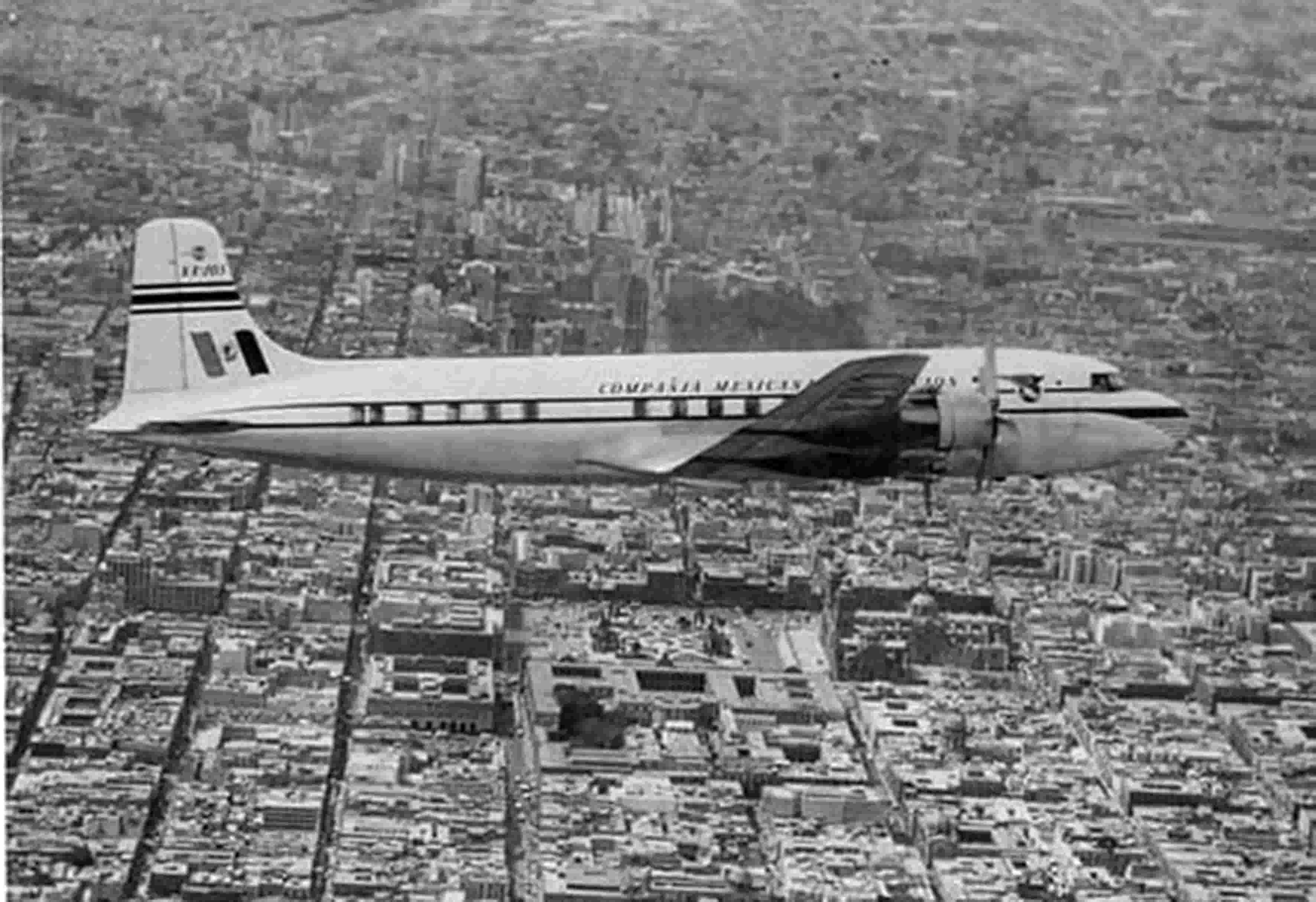
In the third part of the 19th century, during the Porfiriato, the use of new technologies, such as the steam engine, began. In England, in 1826, construction began on the world's first railroad line between two cities, Liverpool and Manchester. Mexico "adjusted with the world, and by 1888 it had considerable railroad lines that connected with the United States and other places such as Veracruz or Tampico," he added.
During the last century, an important factor that triggered growth was the internal combustion engine. Porfirio Díaz, Francisco I. Madero, Venustiano Carranza, and Francisco Villa drove or traveled in cars that only the wealthy owned. The first motorcycles, tractors, and trucks were also manufactured, says the university professor.
"The streets of the cities were empty of cars until the 1940s". Today, there is accelerated motorization and according to preliminary figures from INEGI, up to July 2021, there are 35 million 496 thousand 168 cars, 461 thousand 545 passenger trucks, and 11 million 234 thousand 304 cargo trucks circulating in the country.
A rapid mode of communication
In the chapter "Las velocidades en los espacios: la articulación territorial del México Contemporáneo" of the aforementioned book, Mendoza Vargas and Garza Merodio refer that the railroad that "reached a wide diffusion in the territory, over time seems to have become slow as a spatial experience and practice, so that new technologies, installed in a close and parallel way, such as highways, established a fast mode of communication. In turn, aviation opened new routes in the territory and surpassed the two previous ones in the speed of movements and exchanges, so its presence prepared the new spaces at an accelerated pace".
From the end of the 19th century, contemporary means of transportation helped transform the country's landscape and were decisive in the creation of new regions, profoundly altering the existing ones. A transcendent and emblematic example of railroad preeminence was the creation of La Laguna, and highway supremacy, the emergence of regions such as those presided by Cancun and Tijuana, or coastlines, such as those of Jalisco and Michoacán. In the consolidation of the latter regions, air transportation also played an important role, they add.
There was a period of demographic growth and an increase in the number of new cities, from 45 in 1930, to 84 in 1950 and 124 in 1960, linked simultaneously and at different speeds in their exchanges through railroads, automobiles, and aviation, say the authors. The production and social proliferation of maps placed geography at the center of cultural changes and the construction of the modern image of contemporary Mexico, they conclude.
Source: UNAM


.jpg)