Google's recommendations for civil society in case of natural disasters
This guide is the result of an analysis of the goals obtained by the group after its work of rescue and support for those affected by the earthquake.

Google Mexico in collaboration with #Verificados19S launched on Tuesday a manual of recommendations for civil society to improve support operations in cases of natural disasters similar to the earthquake of September 19, 2017.
This guide is the result of an analysis of the goals obtained by the group after its work of rescue and support for those affected by the earthquake, after a year and a half of joint work with the US company.
The Disaster Communication Manual is a systematization of experience that answers three basic questions: what do I need to operate an intelligence centre that processes information? What technological platforms help to process said information? and what can be improved from the operation so that in another case of disaster more lives can be saved?
The members of the organization, oriented to implement technological solutions for natural disasters, emphasized that, although verified information is always scarce in catastrophic events, civil society can have a strategic role in such situations; capturing, organizing, and sharing the data. The internet is a fundamental channel to achieve access to as many people as possible.
The manual highlights three online platforms. In order of relevance are Twitter, WhatsApp, and Telegram. Each one serves different things; in the case of the first, it allows to the collection of effective information due to the real-time update of disasters, as well as the use of hashtags and images. Whatsapp and Telegram, on the other hand, are good applications to share your location and generate trust groups that facilitate collaboration.
During the presentation of the manual, its creators stressed the importance of standardizing information and processing it. To this is added the update periodicity, key in any platform used by the rescuers so that it does not become obsolete.
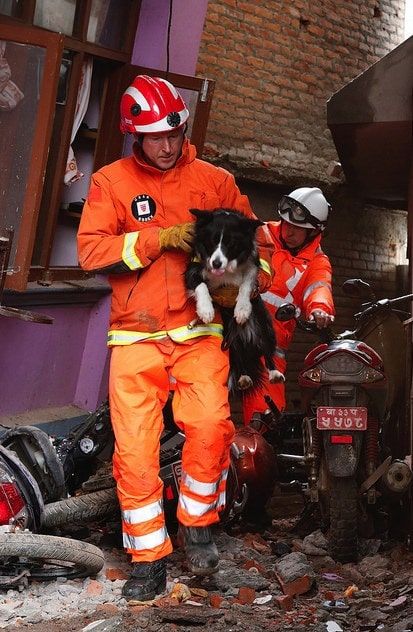
After the catastrophe that occurred on September 19, the lack of up-to-date, accurate, and clear information motivated the architect Sergio Beltrán-García to generate a map to geographically locate the buildings of the city that had suffered damage. Although at first this was corroborated by the same, he soon realized the titanic task it would represent. In social networks, such as Twitter and WhatsApp, their contacts began to report more areas damaged by the earthquake.
The development of the digital map reached its limit, My Maps had been overtaken by the amount of information. It was there when it was decided to request the support of Google to facilitate the use of the same map by the intelligence team.
The operation of #Verificados19s and Google Mexico during the emergency consisted of two main axes. The first was the generation of a map aimed at locating key sites in the emergency. The second was the digital strategy on Twitter, aimed at spreading specific needs in critical areas. Both helped the community identify and promote the necessary help.
In a press conference, the authors highlighted the lessons learned from the September 19 earthquake. In the specific case of people who were operating in the field, it was pointed out that the use of digital forms was not useful for the management of demand in zero zones, due to the urgency and speed with which the situation changed in these places.
Because the coordinators who served as brokers were in charge of managing all the information that arrived, in the end, the operation was centralized, making it indispensable to a small group of people, who in many cases, did not have the preparation or tools to operate in the disaster.