Cortés map, the first representation of the great Tenochtitlan
Cortés map is "a treasure" also known as the Nuremberg map. The document is inscribed between two historical conditions: the Mesoamerican and European worlds. The work integrates a journey and a military location.

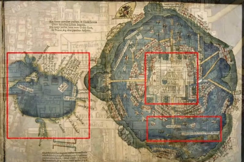
Published in 1524, the Second Letter of Relation of Hernán Cortés was printed together with a map of Tenochtitlan that soon conquered the European imagination by showing, for the first time, a representation of the capital of the Tenochca empire and its basin, governed by the triple alliance of Texcoco, Tlacopan, and Mexico-Tenochtitlan, headed by the Huey Tlatoani, Moctezuma Xocoyotzin.
Currently, this treasure, printed in Nuremberg, Germany, is kept at The Newberry Library in Chicago, which gave the National Autonomous University of Mexico a facsimile of this, the oldest map of Mexico City, as part of the relationship between the two institutions. Shown as a medieval city in the middle of a lake, this first representation of the great Tenochtitlan corresponded to the splendor, wonder, and exoticism described by the conqueror in his Second Letter, written in June 1520 after his flight during the so-called "sad night".
Around the Tenochca ceremonial center described as a "temple where they sacrifice", the conquering imagination of the European artist drew irregular groups of houses with medieval roofs and towers over the water, as if it were Venice or Bremen. The miniaturist landscape completed small villages on the shores of the lake, illustrating the urban centers of Tacuba, Azcapotzalco, Texcoco, Iztapalapa, and Tacubaya, among others.
There is no doubt that the gouges of this hand-colored woodcut must have belonged to an artist from the old continent who, presumably, would have based his work on a sketch sent by Cortés himself to Emperor Charles I, King of Spain. But the logic of graphic organization was due, with all certainty, to the hand or idea of a Nahua tlacuilo.
In the event called "The map of Tenochtitlan that conquered Europe", organized by the Institute of Historical Research (IIH) and the UNAM-Chicago Extension School, the coordinator of Humanities of the National University, Guadalupe Valencia García, on behalf of the rector Enrique Graue Wiechers, thanked the delivery of the facsimile to this house of studies. He also recalled that the 500 years since the fall of Mexico-Tenochtitlan are the subject of an academic program of research and dissemination that places UNAM as a place for the dissemination of knowledge, where we can make a critical review of the Conquest and contribute to the knowledge of ourselves.
Fruitful cooperation
Speaking at the event, UNAM's Coordinator of International Relations and Affairs, Francisco José Trigo Tavera, highlighted that the relationship between this institution and The Newberry dates back several years, but was formalized in 2011 with the signing of a collaboration agreement. Since then, researchers and students, particularly graduate students, have had invaluable access to this U.S. institution that holds, among other treasures, more than 600,000 historical maps.
The collaboration was renewed and includes the institutes of Geography, as well as Historical, Philological, Aesthetic and Bibliographic Research, and the Centers for Foreign Education and Research on Latin America and the Caribbean. "With the momentum of the agreement, the president of The Newberry Library, Daniel Greene, has had the gesture of delivering this precious gift: a high-quality facsimile of the Cortés map." During the distance session, he highlighted the key role that UNAM-Chicago has played in the relationship between the two institutions.
The Newberry collection, made up of 600,000 maps, was created for preservation and research, among other purposes. And as part of it, the map, also known as the Nuremberg map, "is a treasure". This document is inscribed between two historical conditions: the Mesoamerican world, where Cortés is involved, and from where his reports, descriptions, and the sketch that was presumably sent to Spain, and the European world, about to enter the schism of Protestantism.
In 1507, Martin Waldseemüller's map was the first to enunciate and baptize the lands of the new world like America. Another famous map is that of Johannes Shöner, from 1515, which spreads the name of the continent and the nature of these extensions throughout Europe, together with that of Pedro Apiano, from 1520.
In Sloane's map of 1530, "Temixtita" appears, the result of Cortés and his reports, which is not considered as just any place, but as a city on the level of others such as Salamanca or Seville, a great capital that keeps wealth, with government and order. The same name appears on a map by Sebastian Münster, 1540. At various levels, the idea of a civilization where "the focus" was the city of Tenochtitlan was projected.
The image of Cortés' map was also contemplated in copies and plagiarisms with some alterations; it is the same model of the exotic American city, which is on its way to civilization but has not yet reached it because it lacks one detail: to be Christianized. The first representation of the Aztec city, based on that of Nuremberg, is that of Benedetto Bordone, from 1528; another example is that of Giovanni Battista Ramusio.
The academic secretary of the IIH, Gibrán Bautista y Lugo, said that two ancient traditions of visual communication converge in the document: the Mesoamerican configuration at the base of the drawing and the cartapacio (notebook) form that printers designed to publish maps-paintings of capitals such as Jerusalem or Rome.
We are talking about a document that was known together with a text, the Second Carta de Relación. "The complete artifact comprising text and map emerged from the defeat. After the flight of the Spaniards was thwarted by the warriors and the Tenocha population of Mexico-Tenochtitlan, Cortes, captain-general of the defeated host, was given the task of writing to Charles I king of Spain."
It is the first account of the internment of the Spaniards in Mesoamerican lands and is the chronicle that made known to the European world, along with that image, the majestic city on the island of the Valley of Anahuac, Mexico-Tenochtitlan, capital of the Mexica political order. The painting of the city is next to the drawing of the Gulf Coast, where they reached the continent; the map integrates a route and a military location. The strength of Cortés' letter and the map can be measured by its rapid circulation on an Iberian and European scale, thanks to its handwritten and printed reproduction, he concluded.


.jpg)
.jpg)